May 2024 Skyview Weather Monthly Newsletter
Feature Article
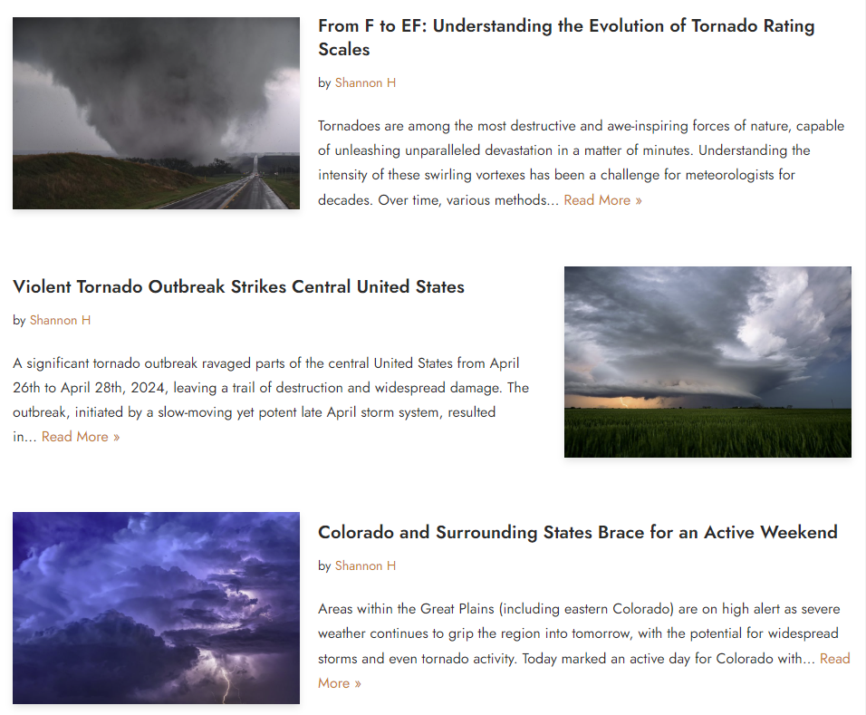
Did you know Skyview Weather Has a Blog?
Skyview Weather is proud to present our comprehensive weather blog, an integral part of our website that offers a deep dive into the world of meteorology. Our blog is a treasure trove of information, featuring a variety of content that caters to both weather enthusiasts and professionals alike. Here’s what you can expect when you visit our blog.
Synoptic Weather Outlooks
Read comprehensive overviews of synoptic-scale (broad-scale) atmospheric conditions. Our synoptic outlooks typically include a discussion on pressure patterns, fronts, wind direction and speed, and how these elements are expected to change and evolve over the coming days.
Storm Summaries and Analysis
Our blog provides comprehensive summaries of winter weather events. Recent coverage includes the active weather weekend in the Great Plains, and an analysis of the heavy, wet snowstorm that hit the Denver metro area last month.
Captivating Weather News
Delve into fascinating weather-related news and features. Our blog has covered events such as the Total Solar Eclipse of April 8, 2024, providing observations, analysis, and a cloud cover outlook for this astronomical spectacle.
Educational Weather Articles & Insights
Broaden your meteorological knowledge with our educational articles. Topics range from the science snowflake shapes and formation, to the role of weather satellites in forecasting. Our pieces are designed to enlighten and inform readers about the complexities of atmospheric phenomena.
Empowering Readers through Weather Education
In addition to our blog content, Skyview Weather provides a growing online Weather Education library. Weather education not only enhances scientific literacy but also empowers individuals to make informed decisions, stay safe during extreme weather events, and appreciate the interconnectedness of our planet’s systems.
Our online Weather Education section contains a collection of weather and climate resources thoughtfully composed by Skyview meteorologists. Readers can access articles about fundamental concepts, such as The Water Cycle and El Nino, or explore advanced topics about lightning or banded snowfall.
Weather education provides essential knowledge useful in everyday life. It empowers individuals and organizations to make informed decisions when faced with weather-related situations. For instance, comprehending basic weather concepts can help mitigate risks and protect oneself, clients, and colleagues from weather hazards like lightning strikes, hail, and flooding.
Moreover, tailored training programs in weather awareness and safety can enhance preparedness within various sectors, including business, public services, outdoor recreation, and industrial facilities. By gaining foundational knowledge about weather systems and severe weather preparedness, people can develop strategies to minimize risks associated with thunderstorms, winter storms, and other severe weather events.
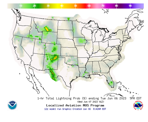
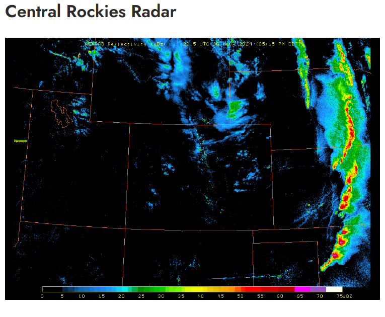
Weather Outlook Tools
As part of our commitment to providing top-tier services, Skyview Weather subscribers now enjoy exclusive access to an array of cutting-edge weather outlook tools. From radar and satellite imagery to lightning probability forecasts and beyond, our suite of weather resources is designed to keep you informed and prepared. Access these tools and live operational weather data by signing into the Skyview Weather online member portal.
Colorado Drought Update
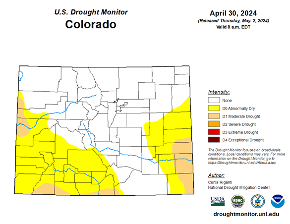
As of May 2024, the drought conditions in Colorado have shown marginal improvement compared to the previous month, particularly in certain areas of southwestern Colorado. Regrettably, the southeastern region of the state has experienced an increase in drought severity due to insufficient precipitation. The drought conditions have escalated from being classified as ‘abnormally dry’ to a ‘moderate drought’, and this has also extended into the eastern regions of the state.
As we transition into the latter part of spring, the state has had a relatively arid commencement to May. Given the current climatic trends and the lack of adequate rainfall, it is anticipated that the drought conditions may exacerbate as the month progresses. It is important to note that the onset of drought in Colorado and across the Intermountain West region can occur rapidly and last from a season to several decades. The state’s reliance on winter snowpack and summer monsoons for water supply further underscores the significance of these climatic conditions. Therefore, continuous monitoring and interstate coordination are crucial to manage the current and future impacts of these drought conditions.
May 2024 Temperature Anomaly Forecast
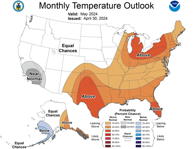
The temperature outlook for May 2024 indicates that portions of the United States are expected to experience temperatures that align with the seasonal norms. Specifically, regions in the Pacific Northwest, Plains, Midwest, and western parts of the country are projected to have an equal likelihood of experiencing average temperatures.
However, temperatures exceeding the average for this time of the year are likely across the Southern, Great Lakes, and Northeastern portions of the country. It is noteworthy that no regions in the US are forecasted to experience temperatures that fall below the average during the month of May.
The temperature patterns observed thus far in Colorado have largely adhered to the seasonal norms, with daily temperatures fluctuating between the low to mid-60s and the low to mid-70s. There have been a few instances of evening temperatures dropping below the freezing point, but such occurrences are expected to diminish as we progress further into the month.
Overall, the temperature anomaly outlook for May 2024 suggests a predominantly average temperature pattern across the United States, with the exception of above-average temperatures expected in the southern and eastern regions.
May 2024 Precipitation Anomaly Forecast
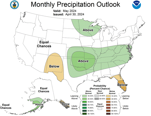
The precipitation outlook for May 2024 suggests that the majority of the United States is expected to receive precipitation amounts that align with the seasonal averages. Notably, the southern plains and the Appalachian regions of the country are projected to have a higher than average likelihood of receiving above-average precipitation.
Conversely, regions south of Colorado extending into New Mexico, as well as most of Florida, are anticipated to experience below-average precipitation. It is noteworthy that the onset of May has been generally mild across most states, and the relatively dry conditions across the Front Range have significantly reduced the precipitation amounts received so far this month.
Colorado April Weather Summary
In April 2024, Denver International Airport (DIA) experienced temperatures slightly above the average, with a mean daily high of 63.9°F and a low of 37.1°F, resulting in an average monthly temperature of 50.5°F. This was 2.7°F higher than the typical monthly average of 47.8°F1. The highest temperature recorded was 80°F on April 14th, while the lowest was 24°F on April 5th.
DIA observed 3.28 inches of precipitation, which is 1.60 inches more than the average for April. Throughout the month, five storm systems were observed, contributing to a total snow accumulation of 6.3 inches at DIA. The most significant snowfall occurred between April 19th and 21st, affecting the northern Metro areas and resulting in a balanced snow distribution across the Denver Metro area into Douglas County.
In the Denver Metro area, snowfall ranged from 3.0 to 6.0 inches, with isolated higher amounts. The foothills and regions above 6,500 feet received 10.0 to 20.0 inches of snow due to elevation and temperature factors.
Southeastern Colorado, including the Colorado Springs area, also reported above-average temperatures. Colorado Springs Airport recorded an average high of 63.8°F and a low of 36.6°F, culminating in a monthly average of 50.2°F, which is 2.7°F above the normal average of 47.5°F2. The warmest days reached 78°F on April 14th, 22nd, and 30th, while the coldest days dropped to 28°F on April 9th and 11th. The airport reported 1.52 inches of precipitation, slightly above the average, with the majority occurring on April 27th.
Pueblo, Colorado, experienced higher-than-average temperatures with below-average precipitation. The average daily high was 70.2°F, with a low of 37.5°F. The peak temperature of 90°F was recorded on April 30th, marking the first occurrence of such warmth for the year. The coldest temperature was 25°F on April 8th. Pueblo received only 1.07 inches of precipitation, which is 0.50 inches below the average for April, with most precipitation occurring on April 27th. Overall, southeastern Colorado saw limited weather events, with only four notable occurrences in April. Warmer conditions led to minimal roadway impacts as most snow melted upon contact with the pavement. Snowfall totals for the Palmer Divide ranged from 5.0 to 9.0 inches, with northern Colorado Springs receiving 0.5 to 2.0 inches, and central to southern Colorado Springs seeing a trace to 0.5 inches. Pueblo and Cañon City reported negligible snowfall for the month.
Weather Statistics for Denver International Airport, April 2024
DIA April 2024 Temperature (°F)
| Observed Value | Normal Value | Departure From Normal | |
| Average Max | 63.9°F | 61.7°F | 2.2°F |
| Average Min | 37.1°F | 33.9°F | 3.2°F |
| Monthly Mean | 50.5°F | 47.8°F | 2.7°F |
| Days With Max 90 Or Above | 0 | 0 | 0 |
| Days With Max 32 Or Below | 0 | 0.5 | -0.5 |
| Days With Min 32 Or Below | 9 | 13.2 | -4.2 |
| Days With Min 0 Or Below | 0 | 0 | 0 |
DIA April 2024 Liquid Precipitation (Inches)
| Observed Value | Date(S) | Normal Value | Departure From Normal | |
| Monthly Total | 3.28” | 1.68” | 0.80” | |
| Yearly Total | ||||
| Greatest In 24 Hours | 1.68” | 04/26-04/27 | ||
| Days With Measurable Precip. | 18 | 14.6 | 3.4 |
May 2024 Preview
The month of May in Colorado is characterized by its climatic variability and is often one of the wetter and cloudier months of the year. It frequently marks the end of the snowfall season for many regions along the I-25 corridor, particularly the Palmer Divide. This year, however, the plains are not anticipated to receive significant snowfall. Nevertheless, the foothills and potentially areas along the Palmer Divide may experience one or two more snow events in the coming weeks.
According to the drought monitor, there are equal probabilities for above or below-average temperatures and precipitation. Given the current onset of May, it appears more probable that temperatures will exceed the norm, while precipitation will be below average for numerous regions of eastern Colorado.
The average high temperatures at the beginning of May are 65°F, escalating to 78°F by the end of the month, a rise of 13°F. Conversely, average low temperatures commence the month at 38°F and conclude at 49°F, an increase of 11°F. These warmer temperatures in May enable individuals to commence their gardening activities as the last frost/freeze of the season typically occurs during the initial weeks. However, as observed in the previous year, a freeze can occur as late as the third or even fourth week of the month. Nevertheless, no further hard freezes are anticipated for the remainder of this year.
Typically, there are three days with temperatures at or below freezing during May. However, if current weather models are accurate, we may avoid a freeze from this point forward. The average monthly precipitation in May is 2.16”, and measurable precipitation is observed on an average of 10 days during the month. This implies that approximately one out of every three days contains some form of moisture.
On the snowfall front, an average of 1.4” of snow falls in May, but many years observe no snowfall at all. It is anticipated that this will be one of those years for Denver International Airport (DIA), as temperatures are expected to remain too warm over the next several weeks.
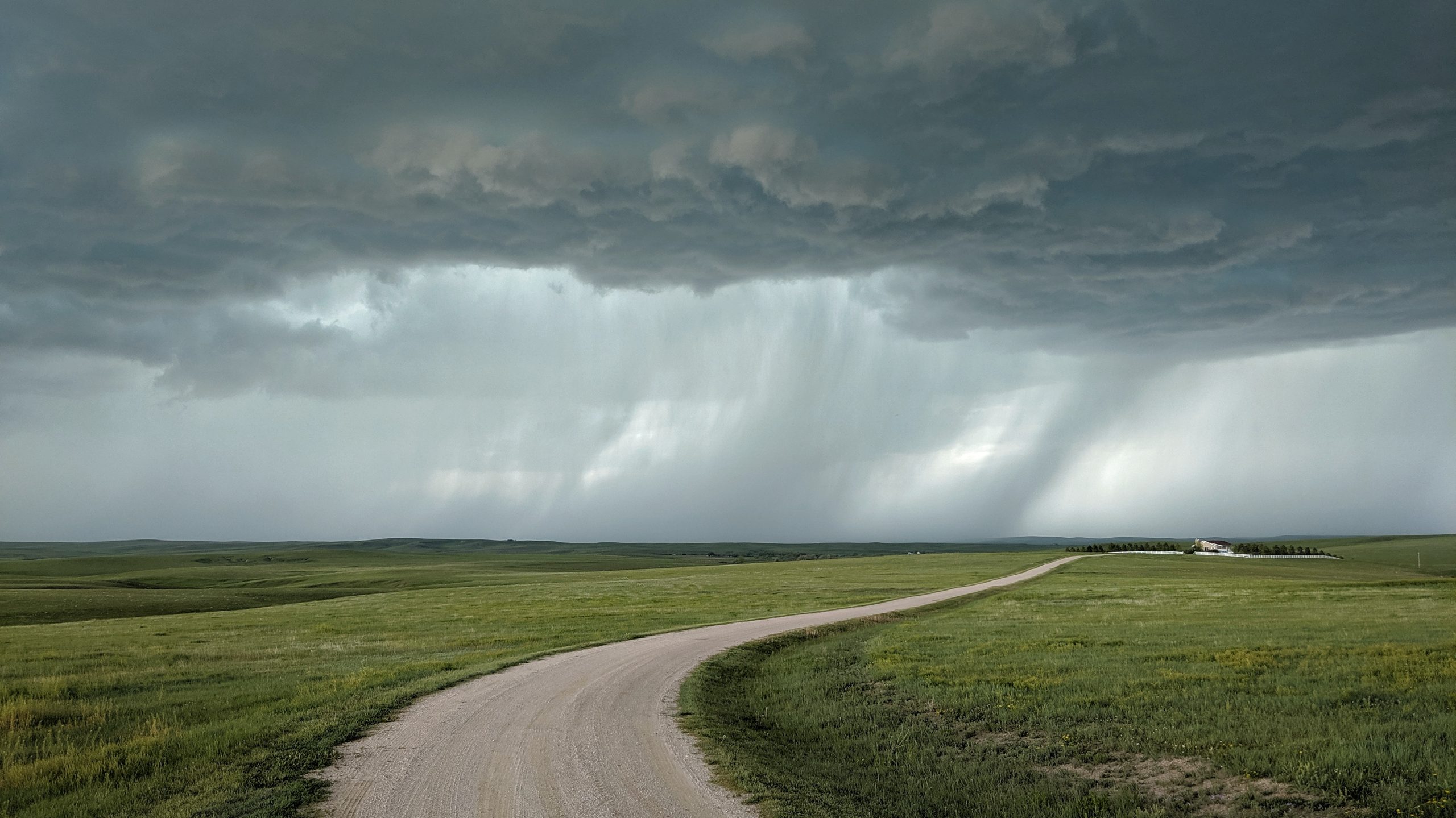
The thunderstorm season commences in May, with typically at least six days during the month experiencing storms that produce thunder. Thunderstorms that develop in May often contain hail, as the freezing levels in the atmosphere are still relatively low following winter. Severe thunderstorms can also develop in May; however, June is the peak month for these types of thunderstorms.
In terms of severe weather potential in northeast Colorado, the month of May often witnesses a lot of extremes, from rain and snow to severe storms and tornadoes. Severe weather season certainly starts to pick up, but some systems can still produce snowfall across the area. In fact, impressive May storm systems in northeast Colorado have been known to unleash hail, tornadoes, heavy rains, and flash flooding.
Denver’s Monthly Temperature, Rainfall, And Snowfall Extremes For May (1872-Present)
Top 20 Warmest May’s
| Rank | Avg | Year |
| 1 | 64.7 | 1934 |
| 2 | 63.2 | 1994 |
| 3 | 62 | 1886 |
| 4 | 61.7 | 1958 |
| 5 | 61.6 | 1974 |
| 6 | 61.6 | 1879 |
| 7 | 61.5 | 1939 |
| 8 | 61.4 | 2018 |
| 9 | 61.3 | 1936 |
| 10 | 61.1 | 1875 |
| 11 | 61 | 1941 |
| 12 | 61 | 1874 |
| 13 | 60.9 | 1963 |
| 14 | 60.9 | 1956 |
| 15 | 60.8 | 1881 |
| 16 | 60.7 | 1977 |
| 17 | 60.6 | 1992 |
| 18 | 60.6 | 1900 |
| 19 | 60.5 | 2012 |
| 20 | 60.4 | 1897 |
Top 20 Wettest May’s
| Rank | Total | Year |
| 1 | 8.57 | 1876 |
| 2 | 7.31 | 1957 |
| 3 | 6.12 | 1969 |
| 4 | 5.53 | 2023 |
| 5 | 5.06 | 1973 |
| 6 | 4.95 | 1935 |
| 7 | 4.88 | 1938 |
| 8 | 4.88 | 1898 |
| 9 | 4.79 | 2011 |
| 10 | 4.77 | 1967 |
| 11 | 4.67 | 1995 |
| 12 | 4.64 | 1987 |
| 13 | 4.61 | 1884 |
| 14 | 4.46 | 1958 |
| 15 | 4.3 | 1883 |
| 16 | 4.26 | 1988 |
| 17 | 4.18 | 1947 |
| 18 | 4.18 | 1912 |
| 19 | 4.15 | 1891 |
| 20 | 4.12 | 1961 |
Top 20 Snowiest May’s
| Rank | Total | Year |
| 1 | 15.5 | 1898 |
| 2 | 13.7 | 1950 |
| 3 | 13.5 | 1978 |
| 4 | 13.2 | 1912 |
| 5 | 12 | 1917 |
| 6 | 10 | 1908 |
| 7 | 9 | 1907 |
| 8 | 8.9 | 1893 |
| 9 | 8.8 | 1957 |
| 10 | 8.3 | 1944 |
| 11 | 8.2 | 1979 |
| 12 | 8 | 1931 |
| 13 | 7.6 | 1983 |
| 14 | 7.2 | 2001 |
| 15 | 1931 | |
| 16 | 7 | 2003 |
| 17 | 6.4 | 1961 |
| 18 | 6.4 | 1915 |
| 19 | 6.3 | 1910 |
| 20 | 6.1 | 1975 |
Top 20 Coldest May’s
| Rank | Avg | Year |
| 1 | 48.7 | 1917 |
| 2 | 50 | 1995 |
| 3 | 50.1 | 1935 |
| 4 | 50.3 | 1907 |
| 5 | 51.4 | 1983 |
| 6 | 51.5 | 1892 |
| 7 | 51.6 | 2019 |
| 8 | 52 | 1946 |
| 9 | 52.6 | 1967 |
| 10 | 52.7 | 1924 |
| 11 | 52.8 | 1943 |
| 12 | 52.9 | 1915 |
| 13 | 53 | 2015 |
| 14 | 53 | 1950 |
| 15 | 53 | 1898 |
| 16 | 53 | 1882 |
| 17 | 53.1 | 2011 |
| 18 | 53.2 | 1885 |
| 19 | 53.3 | 1909 |
| 20 | 53.4 | 1953 |
Top 20 Driest May’s
| Rank | Total | Year |
| 1 | 0.06 | 1974 |
| 2 | 0.09 | 1886 |
| 3 | 0.15 | 1899 |
| 4 | 0.22 | 1919 |
| 5 | 0.34 | 1977 |
| 6 | 0.34 | 1966 |
| 7 | 0.43 | 1925 |
| 8 | 0.49 | 1972 |
| 9 | 0.52 | 1911 |
| 10 | 0.53 | 1900 |
| 11 | 0.6 | 1954 |
| 12 | 0.6 | 1921 |
| 13 | 0.64 | 1970 |
| 14 | 0.65 | 1984 |
| 15 | 0.68 | 1963 |
| 16 | 0.71 | 2005 |
| 17 | 0.71 | 1968 |
| 18 | 0.75 | 1903 |
| 19 | 0.75 | 1873 |
| 20 | 0.82 | 2013 |
Top 20 Least Snowiest May’s
| Rank | Total | Year |
| 1 | – | – |
| 2 | – | – |
| 3 | – | – |
| 4 | – | – |
| 5 | – | – |
| 6 | – | – |
| 7 | – | – |
| 8 | – | – |
| 9 | – | – |
| 10 | – | – |
| 11 | – | – |
| 12 | – | – |
| 13 | – | – |
| 14 | – | – |
| 15 | – | – |
| 16 | – | – |
| 17 | – | – |
| 18 | – | – |
| 19 | – | – |
| 20 | – | – |
May Climatology for Denver
(Normal Period 1991-2020 Dia Data)
Temperature
| Average High | 71.2°F |
| Average Low | 43.6°F |
| Monthly Mean | 57.4°F |
| Days With High 90 Or Above | 0.8 |
| Days With High 32 Or Below | 0 |
| Days With Low 32 Or Below | 2.9 |
| Days With Lows Zero Or Below | 0 |
Precipitation
| Precipitation | Observed Value |
| Monthly Mean | 2.16” |
| Days With Measurable Precipitation | 10.4 |
| Average Snowfall In Inches | 1.4” |
| Days With 1.0 Inch Of Snow Or More | NA |
Miscellaneous Averages
| Heating Degree Days | 261 |
| Cooling Degree Days | 26 |
| Wind Speed (Mph) | 6.3 mph |
| Wind Direction | South |
| Days With Thunderstorms | 6 |
| Days With Dense Fog | 1 |
| Percent Of Sunshine Possible | 64% |
Extremes
| Record High | 95 on 5/26/1942 |
| Record Low | 19 on 5/3/1907 & 5/2/2013 |
| Warmest | 64.7 in 1934 |
| Coldest | 48.7 in 1917 |
| Wettest | 8.57 in 1876*, * -Wettest month in Denver history! |
| Driest | 0.06” in 1974 |
| Snowiest | 15.5” in 1898 |
| Least Snowy | 0.0” in numerous years |
Winter 2023/2024 Snowfall Accumulation for the Colorado Eastern Plains
| City | Oct | Nov | Dec | Jan | Feb | Mar | Apr | Total |
| Aurora | 6.6 | 2.3 | 10.4 | 3.9 | 11.6 | 17.5 | 3.1 | 55.4 |
| Boulder | 5.0 | 7.8 | 9.2 | 8.5 | 13.9 | 19.1 | 5.2 | 68.7 |
| Brighton | 4.7 | 4.0 | 1.1 | 2.2 | 7.8 | 8.8 | 4.5 | 33.1 |
| Broomfield | 4.3 | 5.3 | 3.2 | 5.1 | 13.9 | 22.3 | 5.4 | 59.5 |
| Castle Rock | 9.0 | 2.1 | 9.7 | 12.1 | 17.4 | 31.1 | 3.4 | 84.8 |
| Colorado Springs Airport | 0.0 | 1.1 | 8.4 | 5.1 | 11.5 | 13.3 | 0.6 | 40.0 |
| Denver DIA | 7.5 | 2.9 | 1.4 | 4.2 | 13.7 | 9.2 | 6.3 | 45.2 |
| Denver Downtown | 5.3 | 2.1 | 6.2 | 4.6 | 10.9 | 12.1 | 5.5 | 46.7 |
| Golden | 10.7 | 14.0 | 14.6 | 13.2 | 37.7 | 54.7 | 20.2 | 165.1 |
| Fort Collins | 5.7 | 9.6 | 0.0 | 3.3 | 5.7 | 11.1 | 4.3 | 39.7 |
| Highlands Ranch | 5.8 | 1.8 | 6.9 | 5.1 | 11.6 | 20.2 | 4.2 | 55.6 |
| Lakewood | 8.6 | 4.1 | 11.3 | 5.5 | 21.3 | 23.0 | 4.8 | 78.6 |
| Littleton | 10.0 | 1.6 | 6.0 | 3.7 | 12.3 | 14.3 | 4.4 | 52.3 |
| Monument | 6.5 | 1.5 | 14.8 | 14.1 | 20.3 | 25.2 | 5.0 | 87.4 |
| Parker | 7.4 | 1.0 | 8.8 | 9.1 | 12.3 | 27.1 | 3.2 | 68.9 |
| Sedalia – Hwy 67 | 10.5 | 3.3 | 9.4 | 12.8 | 20.0 | 35.6 | 4.0 | 95.6 |
| Thornton | 4.0 | 4.4 | 4.4 | 4.4 | 12.8 | 12.5 | 5.8 | 48.3 |
| Westminster | 5.1 | 4.7 | 5.3 | 4.8 | 13.7 | 20.0 | 4.4 | 58.0 |
| Wheat Ridge | 6.0 | 3.4 | 6.9 | 5.3 | 22.1 | 22.6 | 6.9 | 73.2 |
| Windsor | 3.5 | 5.5 | TR | 4.9 | 9.0 | 11.0 | 4.0 | 37.9 |
The Skyview Weather Newsletter is a monthly publication that aims to provide readers with engaging and informative content about meteorological science. Each issue features articles thoughtfully composed by Skyview’s team of meteorologists, covering a wide range of topics from the birth of Doppler Radar to the impact of weather phenomena. The newsletter serves as a platform to share the latest advancements in weather forecasting technology and the science behind it, enhancing our understanding of weather.
Skyview Weather has been a pillar for reliable weather services for over 30 years, providing unparalleled forecasts and operations across the Continental US. We offer a comprehensive suite of services that range from live weather support to detailed forecasts, extensive weather data collection, and weather reporting. Our clients, ranging from concert venues to golf courses, theme parks to hotels, schools to police departments, and more, rely on Skyview Weather for winter and summer weather alerts, now available on the Skyview Weather mobile app. These alerts cover a broad spectrum of weather conditions, including snow, lightning, hail, tornadoes, severe weather, and heavy rain. Learn more about how Skyview Weather products and services can support your organization through severe, winter, flood, and fire weather.