The El Niño Southern Oscillation: A Comprehensive Examination
What is El Niño?
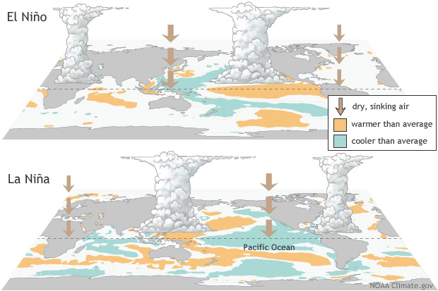
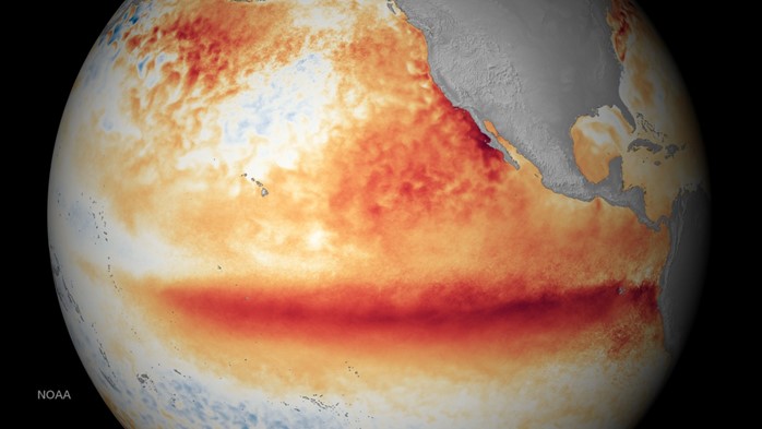
El Niño is a climate pattern that describes the unusual warming of surface waters in the eastern equatorial Pacific Ocean. This phenomenon is part of a larger climate pattern known as the El Niño-Southern Oscillation (ENSO). During El Niño, trade winds weaken, pushing warm ocean water east toward the west coast of South America. This shift in ocean temperatures and atmospheric conditions can significantly influence weather patterns, ocean conditions, and marine fisheries worldwide.
On the other hand, La Niña is considered to be the counterpart to El Niño. It is a climate pattern that describes the cooling of surface-ocean waters along the tropical west coast of South America. During La Niña events, trade winds are stronger than usual, pushing warm water toward Australia. The displacement of this large body of warm surface water encourages upwelling off the west coast of South America. Upwelling is a process by which cold, nutrient-rich, deep ocean water is transported to the surface. Like El Niño, La Niña can also significantly affect global weather patterns.
Measuring and Tracking Ocean Temperatures
Sea surface temperature (SST) provides fundamental information on the global climate system. SST is an essential parameter in weather prediction and atmospheric model simulations. To measure SST, scientists deploy temperature sensors on satellites, buoys, ships, ocean reference stations, and through marine telemetry. The NOAA-led U.S. Integrated Ocean Observing System (IOOS®) and NOAA’s Center for Satellite Applications and Research (STAR) merge their data to provide SSTs worldwide.
Forecasting El Niño and La Niña Phases
Forecasters at NOAA’s Climate Prediction Center (CPC), the nation’s official source for monitoring and forecasting the El Niño-Southern Oscillation (ENSO), rely on a variety of observations from satellites, moored buoys, drifting buoys, sea level analysis, and ships. With this information in hand, NOAA’s Climate Prediction Center tracks and forecasts the development of El Niño and La Niña. Historical and real-time weather data are collected and a team of climatologist’s piece together a probabilistic forecast months into the future.
The Mechanics of the Southern Oscillation
The Southern Oscillation is the accompanying atmospheric component of the El Niño/Southern Oscillation (ENSO), which is coupled with the sea surface temperature changes of the El Niño/La Niña cycle. This oscillation describes changes in air pressure patterns in the Southern Pacific Ocean between Tahiti, in the middle of the southern Pacific Ocean, and Darwin, Australia, to the west. Normally, lower pressure over Darwin and higher pressure over Tahiti encourages air movement from east to west.
The Southern Oscillation Index (SOI)
The Southern Oscillation Index (SOI) is a calculated value used by climatologists and atmospheric scientists to track changes of the El Niño/La Niña cycle over time. SOI values are calculated utilizing SST and atmospheric pressure off the coast of western equatorial South America. Positive SOI values indicate the ocean current is in the La Niña position, while negative SOI values indicate the El Niño position. The SOI time series, including the most current observation, can be viewed on the NOAA SOI monitoring page.
The Global Impact of the El Niño/Southern Oscillation
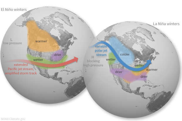
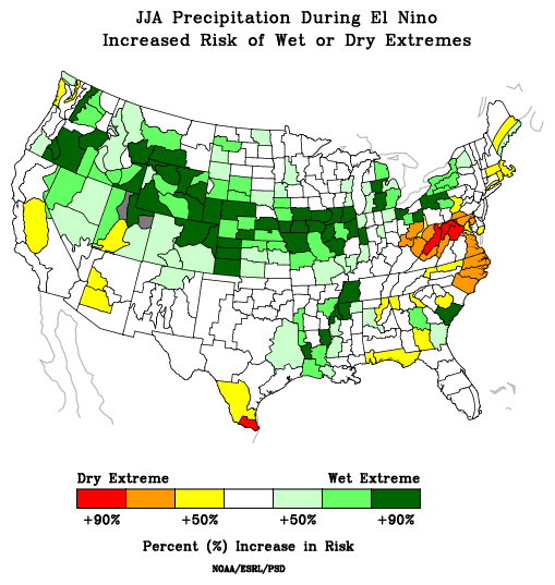
During El Niño, extreme weather events such as prolonged droughts and super cyclones are more likely to develop across the Pacific Basin. More broadly, changes in temperature, pressure, and wind flow patterns along the equatorial Pacific during El Nino cause jet streams to shift globally. This shift immediately affects weather patterns on all continents, often supporting turbulent and abrupt temperature swings, unseasonable weather systems, and extended heat waves.
ENSO has major worldwide social and economic consequences through its global scale effects on atmospheric and oceanic circulation, marine and terrestrial ecosystems, and other natural systems. It affects agriculture, public health, freshwater availability, power generation, and economic activity in the United States and around the globe.
ENSO and Climate Change
Climate change is projected to increase the frequency of extreme El Niño and La Niña events from about one every 20 years to one every 10 years by the end of the 21st century under aggressive greenhouse gas emission scenarios. The strongest El Niño and La Niña events are also expected to become more intense than they are today.
In a warming climate, rainfall extremes are projected to shift eastward along the equator in the Pacific Ocean during El Niño events and westward during extreme La Niña events. The potential evolution of rainfall patterns in the mid-latitudes is less clear, but current trends over the last 30 years suggest extreme rain and drought events, as well as seasonal rainfall patterns will intensify if strong El Niño and La Niña events increase in frequency and amplitude.
The Significance of ENSO
The El Niño and La Niña phases play a crucial role in global climate patterns. Understanding this phenomenon is essential for accurate weather forecasting and climate modeling. The impacts of climate change on ENSO are a subject of ongoing research in the atmospheric science community, which is pivotal for understanding future climate patterns. Raising public awareness about the effects of the El Niño/La Niña phenomenon can help people plan ahead with appropriate adaptation strategies.
If you liked this article, check out Skyview Weather’s growing library of educational weather and climate content. Skyview Weather also offers comprehensive in-person and virtual weather education and weather safety training classes to ensure you and your staff are informed and prepared for severe, winter, and fire weather.