On May 27, 1997, a deadly severe weather episode unfolded across Central Texas, etching itself into the annals of meteorological history. This day is remembered for one of the most powerful and devastating tornadoes ever recorded: an F5 tornado that obliterated the Double Creek Estates subdivision in Jarrell, Texas. The tornado, which displayed some of the most extreme damage ever documented, left an indelible mark on the region and the field of meteorology.
Event Summary
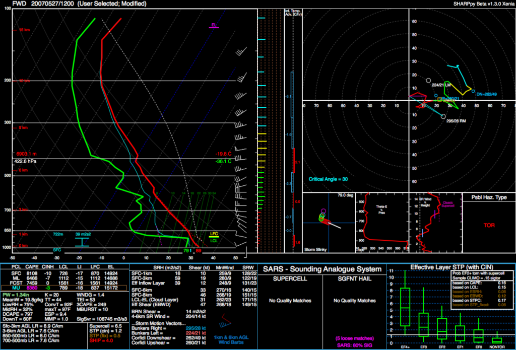
The severe weather event on May 27th was particularly notable not just for the sheer power of the tornado it produced, but also for the unusual atmospheric conditions in which it developed. Typically, tornadoes of such magnitude are associated with strong upper-level forcing and significant wind shear. However, the setup on this day lacked these elements, featuring generally light winds throughout the troposphere. Despite this, 20 tornadoes touched down across Central Texas within a span of six hours, the most destructive of which was the Jarrell tornado.
Atmospheric Conditions and Initiation
On the morning of May 27th, the large-scale weather pattern included a northward-lifting upper-level low pressure system over Nebraska and South Dakota. This resulted in weak mid-level flow over Texas, with most large-scale lift displaced far to the north. At the surface, a cold front stretched southwestward from a low near Fayetteville, Arkansas, through Central Texas. This front would later serve as a key feature in the development of the thunderstorms.
Around noon, a meso-low and a southwestward-propagating gravity wave, identified through satellite imagery, converged near Waco. This convergence area became the initiation point for the supercell that would eventually spawn the Jarrell tornado. Despite the lack of strong vertical wind shear, the environment was characterized by extremely high instability, with Convective Available Potential Energy (CAPE) values exceeding 6500 J/kg, creating conditions ripe for severe thunderstorm development.
Timeline of the Tornado Outbreak
12:00 PM – 2:30 PM:
Thunderstorm initiation occurred just before noon near Waco, right at the intersection of the cold front and meso-low. By 1:21 PM, as the storm moved southwestward, a Tornado Warning was issued due to rapidly increasing low-level rotation. The first tornado of the day, an F3, touched down near Moody, demonstrating the potential for significant destruction.
2:30 PM – 4:00 PM:
The storm continued to intensify as it moved southwestward. Near 2:30 PM, another tornado developed near Morgan’s Point Resort, causing severe tree damage and destroying several homes. As the supercell moved toward Salado, it produced multiple brief tornadoes, including one near Prairie Dell around 3:00 PM. This particular tornado soon evolved into the catastrophic Jarrell tornado.
The Jarrell Tornado
The damage path associated with the Jarrell tornado began in Bell County, about 0.8 miles northwest of the Prairie Dell exit from Interstate 35, near mile marker 280. Initially, the tornado tracked south-southwestward across open country, primarily damaging trees and a few structures. It then crossed the Bell/Williamson County line near where Williamson Road ends and County Road (CR) 304 begins, ripping off approximately 525 feet of asphalt from each of the county roads it crossed. Eyewitnesses reported seeing several small, rope-like funnels before the tornado intensified dramatically into a wider and more powerful vortex.
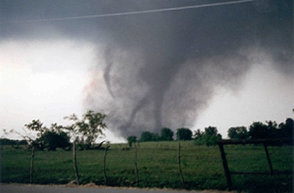
As the tornado approached Jarrell, it destroyed a business at the intersection of CR 305 and 307 and moved into the Double Creek Estates subdivision, where F5 destruction began. The tornado widened to a maximum width of three-quarters of a mile, scouring the earth and leaving a path of total annihilation. Approximately 40 structures in the Double Creek area were completely destroyed, and 27 people lost their lives. The distinct lack of large debris and the pulverized nature of the remaining materials highlighted the tornado’s incredible strength.
After devastating Double Creek Estates, the tornado crossed CR 309 and moved into a heavily wooded area of cedar trees. The path of total destruction ended abruptly, although a small swath of tree damage on the north side suggested the possibility of a multiple vortex pattern. However, no definitive evidence of multiple vortices was observed.
Analysis and Aftermath
The Jarrell tornado was an anomaly in many respects. Despite the lack of typical tornado-producing conditions such as strong upper-level winds and significant wind shear, the extreme instability in the atmosphere provided sufficient energy for the development of this historic tornado. The event underscored the importance of understanding and forecasting severe weather in less-than-ideal scenarios.
The aftermath of the Jarrell tornado was a sobering reminder of nature’s unparalleled power. The National Weather Service (NWS) conducted extensive surveys and studies to understand the factors leading to the tornado’s formation and its unprecedented intensity. These studies have contributed to improved forecasting techniques and a greater appreciation of the complexity of severe weather phenomena.
Conclusion
The F5 Jarrell tornado of 1997 stands as one of the most powerful and devastating tornadoes in recorded history. Its formation under atypical conditions challenges meteorologists to continually refine their understanding of severe weather dynamics. The legacy of this event is a testament to the resilience of the affected communities and the ongoing efforts to enhance weather prediction and public safety.