As the seasons transition and the grip of winter slowly releases its hold, the atmosphere begins to stir with the promise of spring. In Colorado and neighboring regions, this transition often announces itself with the booming arrival of thunderstorms. Tomorrow marks the onset of these springtime spectacles, with the first signs of widespread convective activity forecasted for Colorado, albeit mild.
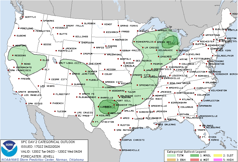
Looking at the Day 2 Convective Outlook from the National Weather Service Storm Prediction Center, dated April 22, 2024 [Fig 1], areas such as northwest Texas and lower Michigan are under a marginal risk of severe thunderstorms for tomorrow. Notably, Colorado is now within a general thunderstorm area on the convective outlook map, which is exciting news for those who love watching lightning and hearing thunder.
In Colorado, where the Rockies meet the Great Plains, the convergence of terrain and atmospheric conditions often gives rise to dramatic weather events. As temperatures rise and moisture levels increase, the stage is set for the clash of warm, moist air from the south and cooler, drier air from the north. This collision fuels the development of towering cumulonimbus clouds, heralding the arrival of thunderstorms.
While Colorado is only expected to receive a few garden-variety thunderstorms, the northwest flow regime, coupled with veering low-level winds and steep lapse rates, creates an environment conducive to severe weather in other areas to the east. In areas like northwest Texas, where strong heating interacts with developing low-pressure systems, the potential for hail and strong gusts looms large. Meanwhile, in lower Michigan, despite cooler dew points, the combination of strong mid-level cooling and convergence along frontal boundaries sets the stage for hail-producing storms.
For residents of Colorado and neighboring states, this forecast serves as a timely reminder to be weather-aware and prepared. As spring storms brew on the horizon, it’s essential to stay informed through reliable sources and head indoors when you hear thunder.
As we embrace the changing seasons and the vibrant energy of spring, let us also marvel at the awe-inspiring spectacle of nature’s fury. From the towering thunderheads to the crackling lightning and rolling thunder, each storm is a reminder of the power and majesty of the natural world.