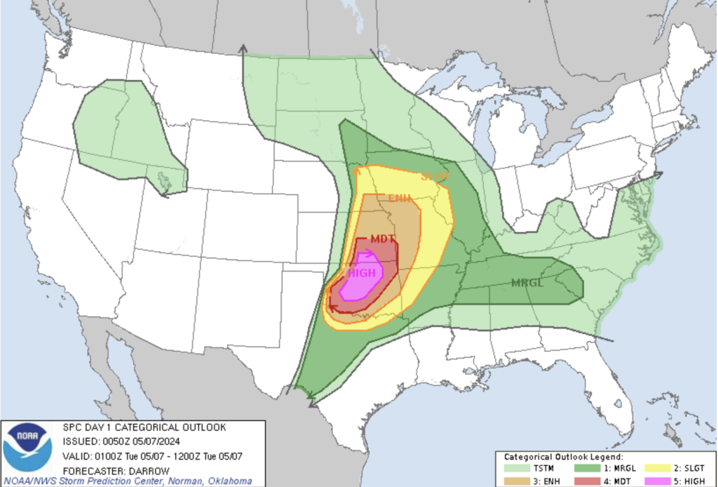
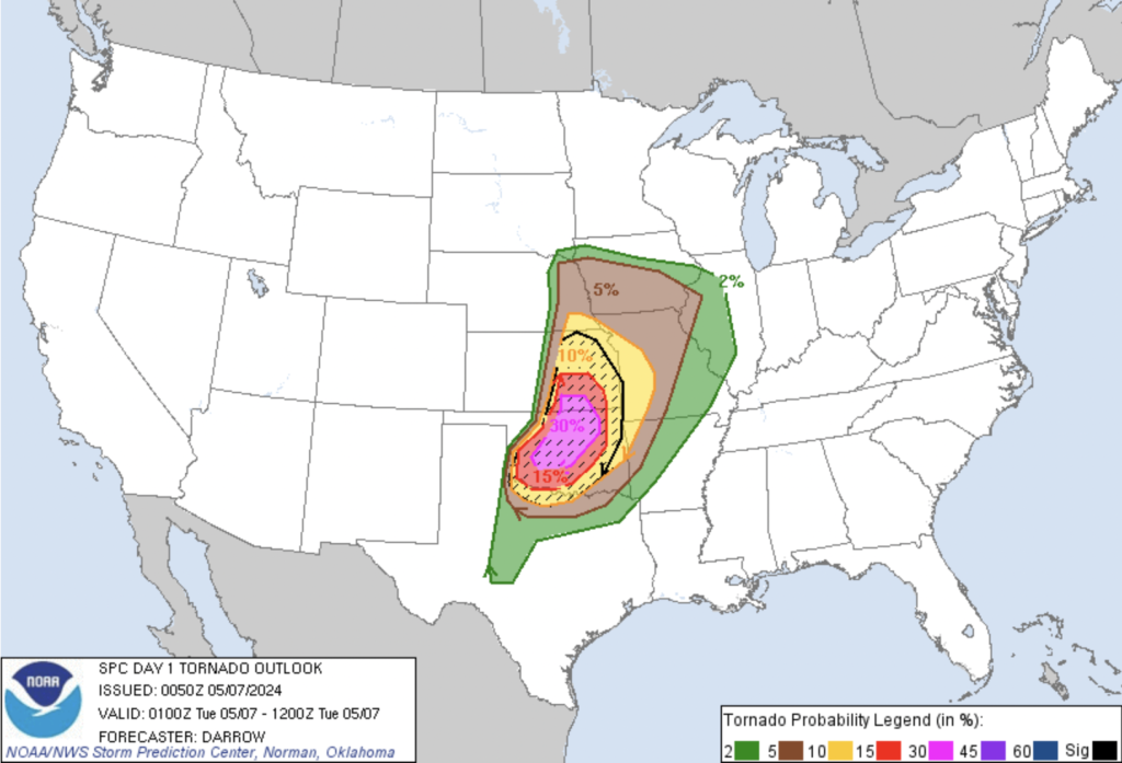
Tonight, many of us are closely monitoring the development of a severe weather outbreak in the south-central Plains, particularly across central Oklahoma and southeast Kansas [Fig 1 and 2]. All the critical ingredients for a significant severe event are aligning as a potent shortwave trough moves into the region, setting the stage for potentially catastrophic weather conditions.
Forecast Overview:
– Ingredients: A convergence of factors, including moisture advection, strong wind fields, and intense instability, is creating an environment ripe for severe thunderstorms.
– Timing: Convective development has begun across northwest and/or western Oklahoma early afternoon through now, spreading east-northeastward into north-central Oklahoma throughout the evening. The threat may persist past midnight in eastern/southeastern areas, although uncertainties remain regarding storm development in these regions.
– Storm Motion: Storms will generally move northeast or east-northeast at speeds of 40-50 mph, with right-moving supercells potentially moving at slightly slower speeds.
Severe Hazards:
– Large to Giant Hail: Diameter exceeding 3 inches.
– Significant, Long-Track Tornadoes: Particularly associated with discrete supercells.
– Damaging Wind Gusts: Especially concerning if high-precipitation supercells or linear storm modes develop.
– Heavy Rainfall: Could lead to localized flooding, especially in areas already saturated from recent rainfall.
High Risk Assessment:
– Storm Mode Uncertainty: While some models suggest a transition to a linear storm mode, others indicate the persistence of discrete supercells. Both scenarios pose significant threats, including tornadoes and damaging winds.
– Tornado Environment: The environment is becoming increasingly favorable for tornadoes as low-level wind shear intensifies and moist, unstable air masses persist, especially after dark.
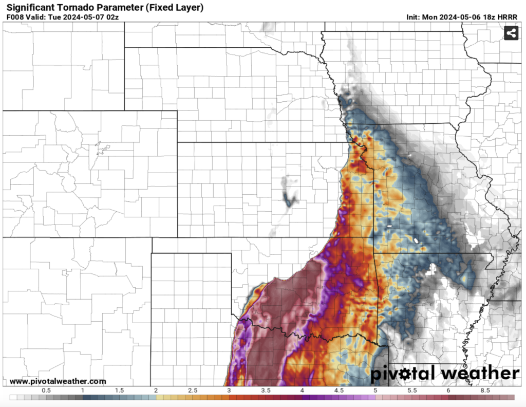
– Significant Tornado Parameter (STP): This composite index, which factors in various tornado atmospherics, is indicative of a high risk for significant tornadoes, particularly over Oklahoma [Fig. 3]. When STP values exceed 1, the risk for tornadoes increases significantly. In the current forecast, STP values are more than double the entire scale, highlighting the extreme risk for tornadoes, especially in central Oklahoma.
– Lifted Condensation Level (LCL): Lower LCL levels increase tornadic risk by suggesting air parcel acceleration closer to the surface.
Latest Mesoscale Discussion Summaries:
– Mesoscale Discussion 0665: The severe weather threat continues across northeast Kansas into southeast Nebraska, with damaging winds and tornadoes being the main hazards. Some discrete activity is ongoing, posing the greatest tornado threat this evening, along with large to very-large hail.
– Mesoscale Discussion 0664: The tornado threat will increase through the evening across northeast Oklahoma into southeast Kansas and extreme southwest Missouri. Local extensions of watch zones and new watch issuance are expected as the evening progresses, with a high probability of severe weather.
– Mesoscale Discussion 0663: An uptick in strong tornado potential is expected through and beyond 9 PM CDT across northwest into central Oklahoma. The environment is volatile, with favorable conditions for strong to intense tornadoes.
– Mesoscale Discussion 0662: A tornado watch will likely be needed this evening as storms move into western portions of Missouri, with the expectation of QLCS tornadoes and damaging winds.
Preparedness Measures:
– Stay Informed: Monitor local weather updates and warnings through trusted sources.
– Have a Plan: Familiarize yourself with severe weather safety procedures, including seeking shelter in a sturdy building or underground if a tornado warning is issued.
– Stay Alert: Remain vigilant of changing weather conditions and be prepared to take swift action if necessary.
While not every area will experience severe weather today, those in the path of developing storms should remain vigilant. Any storm that develops has the potential to unleash significant severe weather, necessitating proactive preparedness and response efforts from residents and authorities alike.