Colorado residents, especially those in the central and eastern parts of the state, should prepare for a continued period of unsettled weather as we move into Monday and Tuesday. The state has already seen two tornado reports in the past 36 hours, including an unusual touchdown in Cripple Creek, a mountain town not typically known for such events. As we enter the new week, the forecast suggests that the threat of severe weather is not yet over.
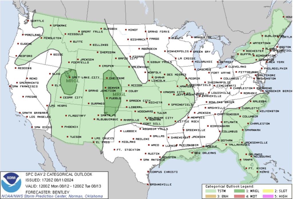
Monday: Widespread Storm Activity with Heavy Rain
Monday will likely bring widespread thunderstorm activity across Colorado. A combination of monsoonal moisture, increased instability, and a mid-level shortwave trough will contribute to the development of numerous thunderstorms, particularly across the central and southern Rockies and the plains. The Storm Prediction Center (SPC) has issued a marginal risk of severe storms for the region.
Storms are expected to initiate over the higher terrain of the Rockies before moving eastward into the plains. The primary threats include heavy rainfall, localized flash flooding, hail, and the possibility of additional tornadoes. The moisture-rich atmosphere, combined with slower-moving storms, increases the risk of flash flooding, particularly in areas with recent burn scars and in urban settings.
The greatest instability on Monday is expected along the Palmer Divide and northeast plains, where MLCAPE (a measure of available energy for storms) could reach between 1,000 and 1,500 J/kg. While wind shear—critical for sustaining severe storms—will be moderate, it should still be sufficient to support a few strong storms. These could produce damaging winds, large hail, and intense rainfall.
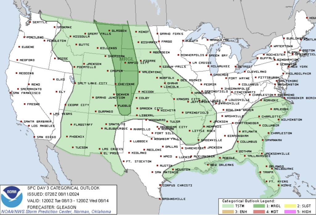
Tuesday: More Organized Severe Weather Threat on the Plains
Tuesday’s weather will still feature severe storm potential, but with a focus on the High Plains. While Monday’s storms may be more widespread, Tuesday’s storms could become better organized due to the evolving weather pattern. An upper-level ridge will persist over the region, but a developing mid-level shortwave trough moving northeastward from the Pacific Northwest will help maintain the instability necessary for more structured storm development.
On Tuesday, the greatest risk will be in the plains east of the Front Range, where an increased threat of severe weather is expected. The NWS has highlighted the potential for isolated severe thunderstorms, capable of producing hail, damaging winds, and heavy rain. The storms that develop on Tuesday may be fewer in number but could be stronger and more organized compared to Monday.
Low-level moisture is expected to increase across the High Plains, leading to steeper lapse rates (the rate at which temperature decreases with height) and greater instability. While mid-level winds may not be particularly strong, the combination of sufficient deep-layer shear and moderate instability should allow for some well-organized storms. These could produce severe hail, damaging winds, and heavy downpours.
What to Expect
- Heavy Rain and Flooding: Both Monday and Tuesday carry the risk of heavy rainfall, which could lead to flash flooding, especially in areas with recent burn scars like the Alexander Mountain burn area. Urban flooding may also be possible.
- Tornadoes: While tornadoes are not the primary threat, the unusual recent activity, including the Cripple Creek tornado, serves as a reminder that these storms can produce twisters, even in mountainous regions.
- Hail and Damaging Winds: Hail up to the size of golf balls and damaging wind gusts are possible with the strongest storms. Residents should be prepared to take shelter if severe weather warnings are issued.
Looking Ahead
As the week progresses, the weather is expected to gradually improve. By Wednesday, a drying trend should begin, leading to near-normal temperatures and fewer storm chances through the end of the workweek. However, the weekend may see another surge in moisture, bringing back the possibility of afternoon and evening storms.
In the meantime, stay weather-aware, especially if you live in areas prone to flooding or where severe storms are forecast.