As Colorado residents rejoice for some rain, it’s essential to stay informed about the severe storm outlook for tomorrow. Here’s a detailed breakdown of what to expect and how to prepare.
Tomorrow’s Outlook (July 16, 2024)
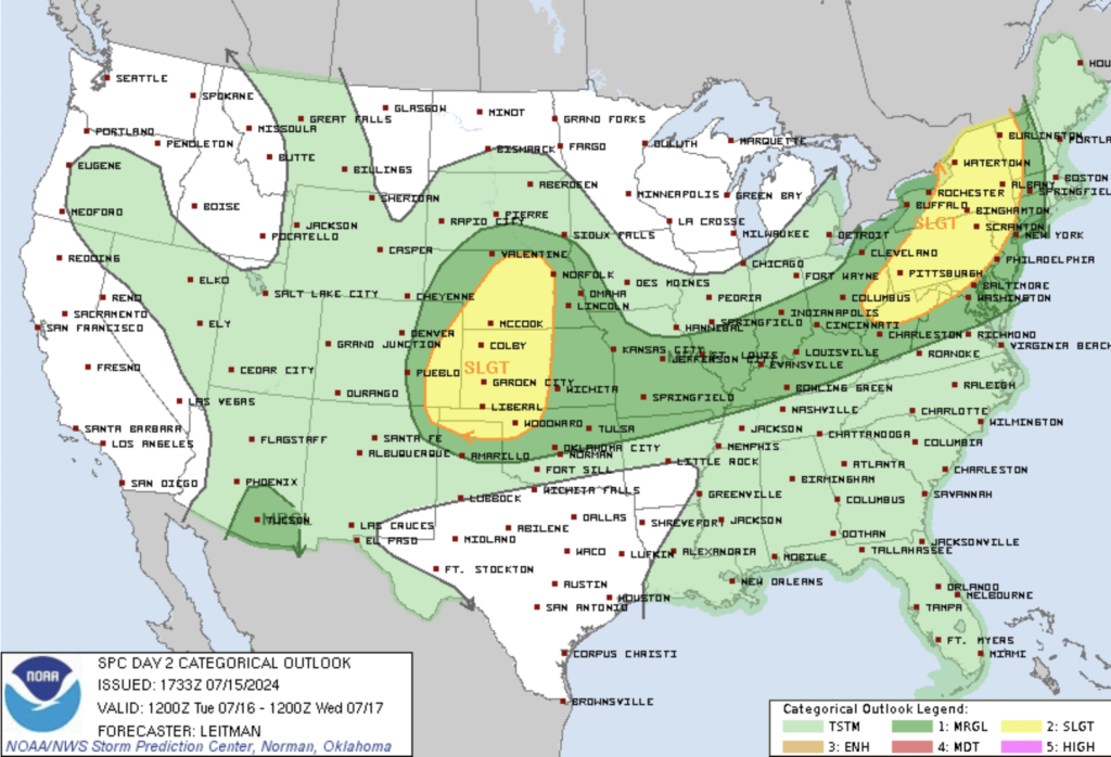
Colorado is looking at a slight risk of severe thunderstorms, particularly in the central High Plains.
Key Points:
– Development: Thunderstorms will likely initiate in the higher terrain of the Rockies, driven by post-frontal upslope flow. As these storms move eastward, they could enter areas of moderate buoyancy over the Colorado Plains.
– Severe Potential: The primary threats include damaging wind gusts and isolated hail. The vertical shear will support organized storm systems, increasing the potential for severe weather. The vertical shear will be around 30-40 knots, strongest over New York and vicinity, and decreasing southward across Pennsylvania into West Virginia/Virginia.
– Storm Characteristics: A very moist airmass combined with strong heating will lead to moderate to strong instability, supporting robust convective development. Organized cells and line segments producing severe/damaging gusts will be the main risk into early evening.
Synopsis:
– Broad cyclonically curved mid/upper flow associated with an upper trough developing east/southeast over the Great Lakes region will extend from the northern Plains to the Northeast.
– At the surface, multiple boundaries will be in place from the Plains to the Midwest, including outflow boundaries associated with Day 1/Mon overnight convection and a couple of cold fronts. Boundary locations and any ongoing convection/cloud debris will impact severe potential during the afternoon and evening.
Colorado is not the only state that may experience severe weather. Other neighboring states like Kansas and Oklahoma as well as further east in areas of Pennsylvania and New York also may see some severe storms.
Upper OH Valley into the Northeast and Mid-Atlantic:
– Forecast guidance has trended further east/south with thunderstorm development, likely due to outflow and a convectively enhanced vorticity maxima tracking across the region by midday.
– A very moist airmass will be in place amid strong heating into the mid 80s (north) to upper 90s (south).
– Vertical shear will be strongest over NY and vicinity (around 30-40 kt effective shear), and decrease with southward extent across PA into WV/VA.
– Organized cells and line segments producing severe/damaging gusts will be the main risk into early evening.
Central/Southern Plains Vicinity:
– A couple of surface cold fronts will sag southward across the Plains on Tuesday. The first will be oriented from northern MO into northwest OK and the northern TX Panhandle during the morning. This front will sag southward and stall across the TX panhandle and northern OK during the afternoon.
– Another cold front will develop southward across the northern Plains into NE by late afternoon, and continue southward across NE/KS overnight.
– A post-frontal upslope flow regime between these two features is expected across western KS into eastern CO.
– Boundary-layer moisture will be somewhat modest across parts of CO/KS/NE (upper 50s to low 60s F dewpoints), with richer boundary-layer moisture along the southern Plains surface boundary (mid/upper 60s F dewpoints).
– Steep midlevel lapse rates will aid in modest destabilization across eastern CO into NE, with strong instability aligned along the TX/OK boundary.
– Both surface boundaries, as well as upslope flow along a surface trough across eastern CO, will focus thunderstorm development during the afternoon and evening.
– More isolated supercell storms are expected to develop across NE, posing mainly large hail and strong gust potential. More widespread coverage is expected across eastern CO/western KS.
– Clustering and consolidating outflow associated with this activity may allow for MCS development by evening. A bowing MCS producing damaging gusts may shift southeast along the instability gradient/surface boundary into the OK/TX Panhandles and northwest OK.
With thunderstorms expected tomorrow, be prepared and keep safety as your top priority. Whether you’re at home, work, or out and about, have a plan in place and be ready to act if necessary. Stay safe!