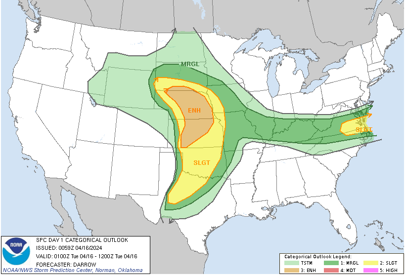
The Great Plains is gearing up for a turbulent evening and overnight as a potent weather system sweeps through the region, bringing with it the potential for severe thunderstorms. While the Denver Metro area may be experiencing its own weather fluctuations, the focus tonight shifts to the central Great Plains and parts of Virginia and Maryland, where an enhanced risk (level 3 out of 5) of severe weather looms large [Fig. 1].
Overview of the Situation
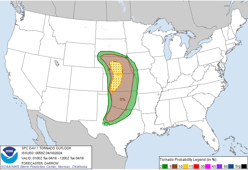
Scattered severe thunderstorms are expected to develop across parts of the Great Plains through the overnight hours, with the potential for several tornadoes [Fig. 2], large to very large hail, and damaging wind gusts. In Kansas and Nebraska, strong tornadoes are a significant concern, while scattered severe gusts are likely in portions of Virginia. As the evening progresses, convective initiation is anticipated, leading to rapid supercell development and the potential for severe weather to intensify.
Key Factors Driving the Severe Weather Outbreak
- Synoptic Setup and Mesoscale Features: The impending severe weather outbreak in Kansas and Nebraska is underpinned by a complex interplay of synoptic-scale weather patterns and mesoscale features. A potent weather system sweeping through the Great Plains is poised to create a highly dynamic atmosphere conducive to severe thunderstorm development, particularly in the central regions of Kansas and south-central areas of Nebraska.
- Moisture Advection and Boundary Interactions: Central to the tornado risk assessment is the advection of moisture-rich air northward across central Kansas into south-central Nebraska. This influx of moisture not only serves as fuel for convective processes but also sets the stage for the development of boundaries such as drylines or outflow boundaries. The interaction of these boundaries with the rich moisture environment can enhance low-level wind shear, a critical ingredient for tornadogenesis.
- Thermodynamic Instability: The atmosphere in Kansas and Nebraska is characterized by significant thermodynamic instability, with Mixed-Layer Convective Available Potential Energy (MLCAPE) ranging from 2000-3000 J/kg. This indicates the presence of ample energy available for deep convection and severe thunderstorm development. Furthermore, the presence of steep lapse rates and ample moisture contributes to the potential for robust updrafts within supercells, which can lead to tornado formation.
- Wind Shear Dynamics and Supercell Potential: The combination of strong deep-layer wind shear and buoyant air masses creates an environment favorable for the development of supercells—long-lived, rotating thunderstorms capable of producing tornadoes. The strong wind shear facilitates the organization and persistence of updrafts, leading to the development of mesocyclones—a precursor to tornado formation. This enhanced wind shear, coupled with the favorable thermodynamic environment, increases the likelihood of tornadic activity in the region.
- Topographical and Land Use Factors: Additionally, the relatively flat terrain characteristic of the Great Plains region allows for unimpeded airflow and enhances the efficiency of storm organization and propagation. This, combined with the predominantly rural landscape, reduces obstacles to tornado formation and allows for more sustained and potentially damaging tornadoes.
Conclusion
As the Great Plains braces for tonight’s severe weather outbreak, it’s crucial for residents to remain vigilant and prepared. By staying informed, taking necessary precautions, and looking out for one another, we can mitigate the impacts of severe weather and ensure the safety of our communities. Let’s stay weather-aware and support each other through this turbulent time.