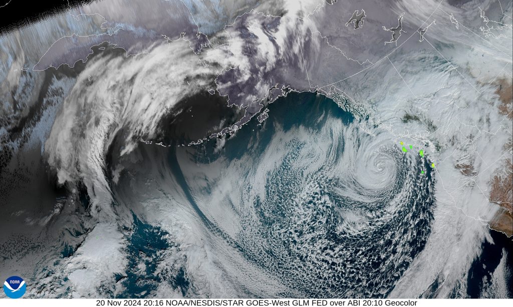
Seattleites are in for a wild ride this week, as a textbook bomb cyclone slams the Pacific Northwest with raw, unrelenting force. From howling winds and towering waves to thunderstorms and unrelenting rain, the storm is offering a textbook lesson in bombogenesis, a rare and intense meteorological phenomenon that can leave even the most seasoned weather watchers in awe.

What is Bombogenesis?
To understand the gravity of this storm, let’s break down the science behind “bombogenesis.” This term refers to the rapid intensification of a midlatitude cyclone, a storm system located between the tropics and polar regions. A cyclone goes through bombogenesis when its pressure drops by at least 24 millibars in just 24 hours—about the difference you might feel when stepping off a plane at high altitude. The more drastic the pressure drop, the more explosive the storm’s power. In Seattle’s case, this particular bomb cyclone has been brewing off the coast, and it’s strengthening as it nears, bringing a whirlwind of chaos with it.
The Storm’s Impact on Seattle
This bomb cyclone, which is expected to potentially set records, is whipping through Seattle’s skies with winds, rain, and even a few surprises thrown in. Winds reached up to 50-60 knots along the coast, with gusts likely to continue as the storm progresses. Along with these powerful winds, the region is facing large waves on the coast, reaching up to 30 feet in some areas. The storm has brought elevated seas, and dangerous bar conditions, especially around Grays Harbor Bar, will be a concern well into the afternoon.
Meanwhile, downtown Seattle is no stranger to the “showers with a twist” forecast. Expect showers throughout the day, with the possibility of thunder and even small hail. These unpredictable bursts are expected to continue, as the low pressure system sits offshore and churns up instability in the atmosphere.
In fact, conditions are so volatile that thunderstorms have been popping up west of Puget Sound, some of them packing a punch with hail. That’s right—hailstorms in November are part of the deal this time around.
The Forecast Ahead: A Messy Weekend
The storm isn’t just a quick hit; it’s staying around for the long haul. The next couple of days will see a mix of scattered showers, wind gusts, and more potential thunderstorms. Temperatures will stay cool, with highs in the mid 40s to low 50s, keeping Seattle firmly in the grip of this unstable weather pattern.
As the storm moves north and deepens even further, we’re looking at another round of rain and wind starting Friday morning. This could push Seattle’s low pressure system to a staggering 975 millibars, possibly triggering more wind advisories along the coast and over the inland areas. High winds could reach gusts strong enough to trigger high wind warnings along the coast.
And if you thought the worst was over, the weekend promises more of the same. While the region might experience a temporary break from the storm Saturday, another powerful low pressure system is brewing and could unleash high seas and powerful winds once again.
On the Horizon: Flooding and Snow
It’s not just the winds and waves that have authorities on edge—rivers are also posing a risk. With heavy rain falling across the South Slopes of the Olympics, the Skokomish River is nearing flood stage, and it could rise again on Friday. Thankfully, snow levels in the Cascades are staying relatively low, limiting runoff and the threat of more widespread flooding.
In the mountains, conditions are equally wild. A winter weather advisory remains in place for the North Cascades, where snow and icy conditions are making travel treacherous, especially over the mountain passes.
The Big Picture: A Rare, Explosive Event
So why does a bomb cyclone like this seem so rare, and why do we see it so rarely in Seattle? The combination of an unusually deep low pressure system and a perfect collision of warm and cold air over the Pacific Ocean creates a powerful storm that strengthens quickly—almost like a kettle boiling over. This kind of bombogenesis is common over the ocean, but when it reaches land, it can be spectacular, and for good reason.
The intense winds, heavy rains, and frigid temperatures are all part of the system’s rapid transformation, making it a rare meteorological event that’s definitely not something you’ll want to ignore.
A Familiar Phenomenon for Coloradoans
For many Coloradans, the term “bomb cyclone” might not sound all that unfamiliar. In fact, the state experienced a memorable bomb cyclone in 2019, when a massive storm rapidly intensified and dropped snow, ice, and heavy winds across the region. This event, which resulted in widespread power outages, severe snowstorms, and dangerous travel conditions, highlighted just how intense these rapidly strengthening systems can be. While this current bomb cyclone over Seattle is playing out on the West Coast, Coloradoans know firsthand how quickly such storms can escalate, packing a punch with both extreme winds and snowfall. So, while the Pacific Northwest is bracing for impact, Coloradans can relate to the ferocity of a bomb cyclone—proof that these explosive storms can strike anywhere.
If you live in Seattle and are planning on stepping outside over the next few days, be sure to batten down the hatches. The bomb cyclone is here, and it’s making quite the impression on the Pacific Northwest. From windswept coastlines to lightning-lit skies over the city, this weather system is one for the history books. Stay safe and stay prepared, because Mother Nature’s explosive storm has Seattle in its sights.
