
February 2026 will go down as one of the most unusual winter months in Denver’s climate history.
Not only are we finishing the month with one of the lowest February snowfall totals on record, but we’ve also seen record warmth, multiple days near or above 70°, and even Red Flag Warnings — something far more common in April than mid-winter.
For a city where the average winter high is just 44°–45°, this simply isn’t typical.
And the bigger picture? This hasn’t been a typical snow season either.
A Winter That Has Felt More Like Spring
If current projections hold, Denver is likely to record at least 40 days at or above 60° between December and February. That’s nearly half of meteorological winter spent at temperatures 15°+ above average.
Instead of consistent cold and snowpack-building storms, we’ve seen:
- Prolonged warm stretches
- Limited arctic intrusions
- Frequent downslope-enhanced warmth
- Dry fuels emerging earlier than normal
The combination of warmth and wind has already elevated fire weather concerns — months before peak fire season typically begins.
The Snowpack Problem
While Denver has struggled with snowfall, the mountains tell an equally concerning story.
Statewide snowpack (SWE – snow water equivalent) is running well below median for late February, sitting around the lower third of historical distribution. Peak snowpack typically occurs in early to mid-April, but we are entering the most important accumulation window already behind normal.
This is critical because:
- March and April are typically Colorado’s snowiest months in the Front Range.
- Mountain snowpack determines spring runoff and summer water supply.
- A weak snowpack combined with early warmth increases wildfire vulnerability.

Drought Conditions Expanding
Across the region, drought has intensified. Portions of Wyoming are now in Severe (D2) to Extreme (D3) drought, and dryness continues to expand across parts of Colorado.
Warm winters can rapidly accelerate drought development because:
- Snowpack melts earlier
- Soil moisture is depleted sooner
- Spring green-up happens prematurely
- Fire danger increases earlier in the season

Why Is This Happening? The ENSO Factor
We are currently transitioning out of La Niña conditions.
In January 2026, sea surface temperatures in the central Pacific remained below average, with the Niño 3.4 index around -0.9°C — still consistent with La Niña. However, subsurface warming across the Pacific has strengthened significantly.
Forecast guidance from the North American Multi-Model Ensemble favors:
- A transition to ENSO-neutral between February and April (60% chance)
- ENSO-neutral likely persisting into summer (56% chance)
- A 50–60% chance of El Niño developing by late summer
La Niña winters typically favor:
- A more active northern storm track
- Drier conditions across the southern U.S.
- Variable impacts for Colorado depending on storm placement
But as La Niña weakens, the atmosphere often becomes more chaotic and less predictable. That appears to be playing out this season, with long stretches of warmth dominating the Front Range.
What to Expect in March
March is Denver’s snowiest month on average. So the big question:
Can March save the season?
Here’s what history and current climate signals suggest:
1. March Can Still Deliver Big Storms
Even in low-snow winters, Denver can pick up significant totals in March. Upslope events remain possible, especially if cold air phases correctly with Pacific moisture.
It only takes one or two strong systems to dramatically shift seasonal snowfall rankings.
2. But Warmth May Continue to Dominate
With ENSO transitioning toward neutral and no strong arctic pattern currently locked in, temperature volatility is likely.
Expect:
- Wide swings (70° one week, snow the next)
- Increased wind events
- Rapid snowmelt after storms
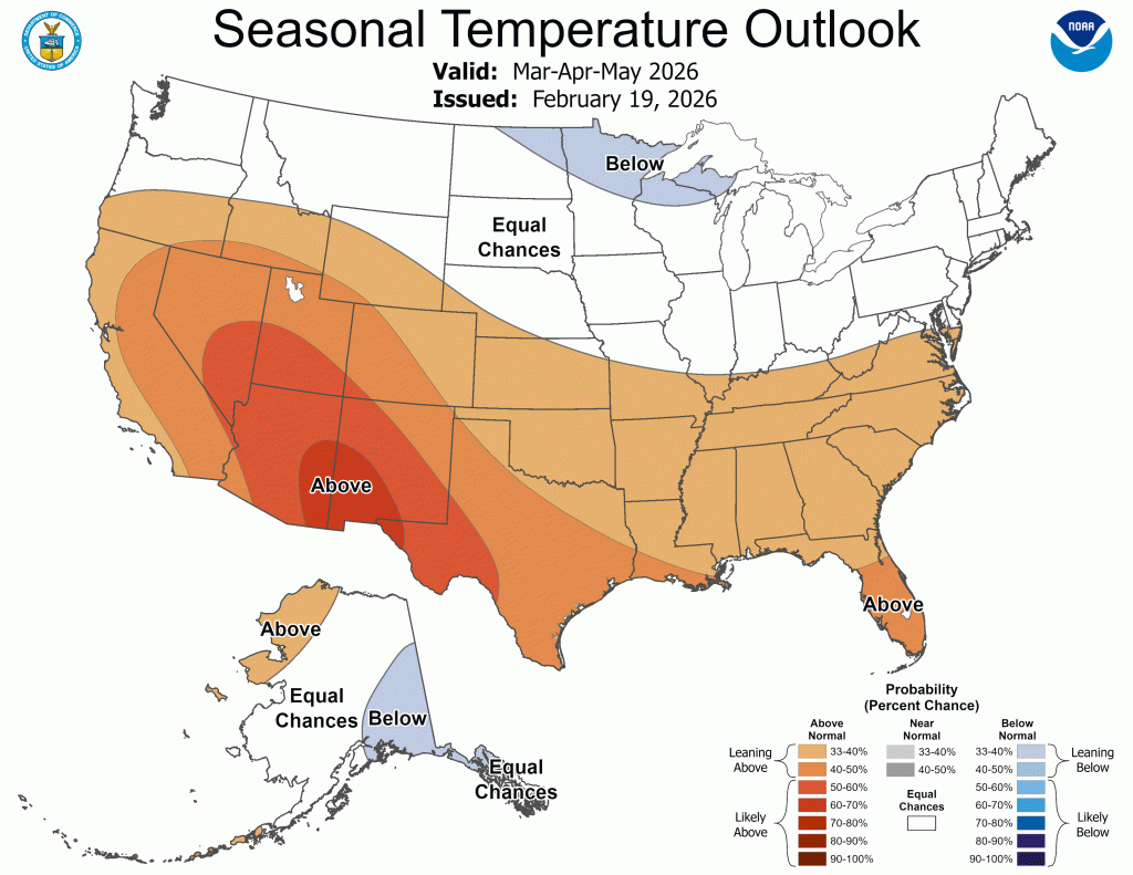
3. Fire Weather Could Become a Bigger Story
If March trends warm and dry:
- Fuels will cure early
- Grass fire risk will increase
- Red Flag Warnings may become more frequent
That’s highly unusual for early March but increasingly plausible this year.
4. Snowpack Recovery Window Is Shrinking
Climatologically, the heaviest mountain snow accumulation occurs from now through mid-April.
If March underperforms:
- Spring runoff will be reduced
- Drought expansion becomes more likely
- Summer fire risk increases

The Bottom Line
This February has been one of Denver’s worst for snow on record — and among the warmest for winter conditions.
Nearly half of winter may finish at 60° or warmer.
Snowpack is below normal.
Drought is expanding.
Fire weather concerns are arriving early.
March remains the final opportunity for meaningful snow accumulation before the seasonal shift toward spring.
In Colorado, winter isn’t over until it’s over — but the window is narrowing.