
February 2024 Skyview Weather Monthly Newsletter
Feature Article
Relocating Weather Stations: The Impact on Denver’s Historical Precipitation Records
Introduction
Meteorology relies heavily on historical climatological data to understand weather patterns and fluctuations over time. The controlled aspect of the data is usually the location of the weather station taking the information, as different locations can vary significantly when it comes to temperatures, precipitation, humidity, etc. Even if those locations are relatively close by. Denver, Colorado, however, provides a fascinating case where the location of weather data collection has moved several times over the course of 150 years. Thus, creating a challenge when it comes to comparing historical records to current weather conditions.
Denver’s Weather Data Collection Over Time
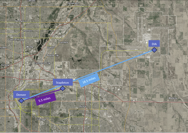
Since its inception in 1872, Denver’s weather data collection has undergone three major relocations, each introducing unique challenges and implications for historical records. The journey began in the downtown area of Denver, where data was diligently recorded until December 1949.
It is worth noting that between 1872 and 1949, the location changed 10 times, however, all were well within 1 mile of each other. Weather patterns largely do not change with such a short distance, and if they do, the changes are minuscule. For simplicity, the first location will be considered “Downtown Denver”.
By 1950, Denver’s official reporting location moved roughly 5.5 miles east-northeast to Stapleton Airport. In March of 1995, the official data collection station was relocated once more to Denver International Airport (DIA), a significant 18.5 miles away from its original location. To put this into perspective, this is roughly the same distance to Lafayette, CO or Parker, CO, where weather is vastly different in comparison to Denver due to elevation and topography differences. Elevation and topography are just some of the factors that differ between locations, for example, DIA does not account for the weather phenomenon known as the “urban heat island” that Denver experiences often.
The Ripple Effect on Precipitation Data
Top 20 Wettest Years (1872-Present)
| Rank | Total | Year |
| 1 | 23.31 | 1967 |
| 2 | 22.96 | 1973 |
| 3 | 22.96 | 1909 |
| 4 | 21.87 | 1965 |
| 5 | 21.58 | 1957 |
| 6 | 21.52 | 1969 |
| 7 | 21.43 | 1891 |
| 8 | 21.42 | 1923 |
| 9 | 20.96 | 1999 |
| 10 | 20.36 | 1979 |
| 11 | 20.32 | 1991 |
| 12 | 20.19 | 1983 |
| 13 | 20.12 | 1876 |
| 14 | 20.03 | 1987 |
| 15 | 19.61 | 1914 |
| 16 | 19.59 | 1997 |
| 17 | 19.49 | 1883 |
| 18 | 19.46 | 1938 |
| 19 | 19.43 | 1951 |
| 20 | 19.01 | 1961 |
The impact of these relocations becomes evident when analyzing precipitation records for Denver, particularly for the year 2023. The Denver International Airport reported 18.94 inches of precipitation during 2023. While this is much wetter than other years, this amount is relatively unremarkable when compared to the top 20 wettest years in Denver per the National Weather Service.
However, the story of 2023’s precipitation in Denver changes significantly when looking into locations closer to the town center. A weather station located within a mile of Stapleton Airport’s control tower recorded 20.40 inches of precipitation in 2023. This significant difference not only places 2023 on the list of the top 20 wettest years but puts it at 10th place, surpassing 1979 at 20.36 inches.
Conclusion
2023 proved to be quite a ‘wet’ year when comparing it to the top 20 wettest years from NWS and is a great example of why one should use caution when comparing historical climate data if the weather station has been moved. This information may present the need for a more nuanced approach to interpreting historical weather records that compares the locations before and after the move(s) of a weather station. Only time will tell if 2024 will follow suit or surpass this year in precipitation amounts.
February Drought Update
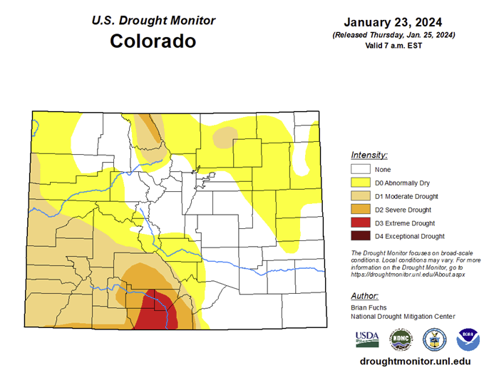
The drought conditions in Colorado have largely remained static since December 2023. A significant portion of the southwestern region of the state continues to experience drought, with the current snowpack having minimal immediate impact. The influence of snowfall on drought conditions will only become apparent once the spring melt commences. In contrast, the eastern plains have seen a reduction in drought conditions. This improvement can be attributed to the unusually high levels of precipitation recorded in January 2024.
February 2024 Temperature Anomaly Forecast
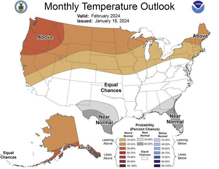
The temperature forecast for February 2024 indicates that conditions are expected to align with the seasonal norms across much of the US. However, regions including the Pacific Northwest, Northern Plains, Great Lakes, and Northeast are projected to experience temperatures that exceed the average for this time of year.
The initial days of February have already exhibited the effects of marginally elevated temperatures. These warmer conditions, in conjunction with high levels of atmospheric moisture, have facilitated the occurrence of rain and the deposition of wet, heavy snowfall across a substantial portion of the Plains region.
February 2024 Precipitation Anomaly Forecast
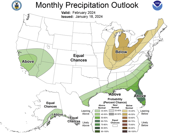
The precipitation forecast for February 2024 suggests that most regions of the United States are expected to receive average levels of rainfall. However, recent meteorological events, specifically the winter storm that occurred on February 2nd, suggest a deviation from this projection. This winter storm was characterized by exceptionally high precipitation levels and set new records in the state of Colorado before progressing eastward. Despite being only one week into February, several areas in Colorado have already reported precipitation levels significantly above the monthly average. Current meteorological models indicate the development of another winter system over the Great Basin. This is likely to further increase the monthly precipitation values.
Colorado January Weather Summary
During January 2024, the Denver Metropolitan area was characterized by temperatures that were predominantly below the seasonal average. Denver International Airport (DIA) reported an average daily high temperature of 41.8°F and a daily average low of 14.5°F. The combined average temperature was 28.2°F, which is 3.6°F below the average monthly temperature of 31.8°F. The highest temperatures were recorded on January 30th and 31st, with DIA reaching 61°F. The coldest days were January 15th and 16th, with temperatures plummeting to -19°F. Regarding precipitation, DIA reported 0.28” of liquid precipitation, which is 0.09” below the average of 0.37” for the month of January.
The Colorado Springs airport exhibited similar weather patterns. The average daily high temperature was 42.7°F, with an average daily low of 17.1°F. The combined average temperature for the month was 29.9°F, which is 2°F below the average monthly temperature of 31.9°F. The warmest day was on January 31st, with the temperature peaking at 65°F. The coldest day was January 15th, with the temperature dropping to -10°F. In terms of precipitation, Colorado Springs Airport reported 0.62” of liquid precipitation, which is 0.34” above the average of 0.28” for the month of January. The majority of this precipitation occurred on the 26th, with 0.33” of liquid precipitation recorded.
Pueblo experienced similar weather conditions, with below-average temperatures and slightly above-average precipitation for the month of January. Pueblo recorded an average daily high temperature of 43.9°F and an average daily low of 14.5°F. The warmest day was January 31st, where the airport reached 65°F. The coldest day was January 16th, where the temperature dropped to -11°F. Precipitation was slightly above average for the Pueblo area, with 0.32” of liquid precipitation recorded, which is 0.04” above the average of 0.28” for January. Most of this monthly precipitation occurred between the 4th and 5th, measuring 0.21” within that 24-hour period.
Several storm systems impacted DIA during the month of January, with four storms reporting over a trace. These events occurred on the 7th-8th (reporting 0.7” total), 12th-13th (reporting 0.9” total), 14th-15th (reporting 2.1” total), and the 25th-26th (reporting 0.5” total). These events account for the total snowfall at DIA during the month. However, the winter storms occurring on January 7th-8th and January 25th-26th were responsible for more snow across the metro region than what was measured at DIA. The storm occurring January 7th-8th produced snow totals between 2.0-6.0”, and the storm occurring January 25th-26th produced snow totals between 1.0-3.0” across the Denver metro.
There were four notable winter events across southeastern Colorado during the month of January. The first took place January 4th-5th where widespread light snow from Colorado Springs and Pueblo produced up to 2.5” of snow accumulation. The second notable event occurred January 7th-8th which produced moderate to heavy snow along the Palmer Divide and in portions of North Colorado Springs. The third notable event took place January 18th-19th where a small band of unexpected snowfall developed over Central and Southern Colorado Springs, producing up to 2.0” of new snow. The final notable event occurred January 25th-26th where widespread light to moderate snowfall blanketed Colorado Springs and Northern El Paso County broadly with 3.0-6.0” of snow.
Weather Statistics for Denver International Airport, January 2024
DIA January 2024 Temperature (°F)
| Observed Value | Normal Value | Departure From Normal | |
| Average Max | 41.8°F | 44.6°F | -2.8°F |
| Average Min | 14.5°F | 18.7°F | -4.2°F |
| Monthly Mean | 28.2°F | 31.7°F | -3.5°F |
| Days With Max 90 Or Above | 0 | 0 | 0 |
| Days With Max 32 Or Below | 5 | 5 | 0 |
| Days With Min 32 Or Below | 31 | 29 | 2 |
| Days With Min 0 Or Below | 7 | 2 | 5 |
DIA January 2024 Liquid Precipitation (Inches)
| Observed Value | Date(S) | Normal Value | Departure From Normal | |
| Monthly Total | 0.28” | 0.38” | -0.10” | |
| Yearly Total | 0.28” | 0.38” | -0.10” | |
| Greatest In 24 Hours | 0.09” | 1/15 | ||
| Days With Measurable Precip. | 5 | 4.4 | 0.6 |
DIA January 2024 Snowfall Accumulation (Inches)
| Observed Value | Date(S) | Normal Value | Departure From Normal | |
| Monthly Total | 3.6” | 6.4” | -2.8” | |
| Seasonal Total | 16.2” | 18.5” | -2.3” | |
| Greatest In 24 Hours | 1.5” | 1/15 | ||
| Greatest Depth | 5 | 4.4 | 0.6 |
February 2024 Preview
The month of February 2024 has already been marked by significant meteorological activity, with a ‘spring-like’ snowstorm traversing Colorado from February 2nd to February 3rd. This storm was characterized by relatively warm low-level temperatures and elevated atmospheric moisture levels. These conditions facilitated the deposition of heavy, wet snow across the metropolitan area and foothills. The map below illustrates total snowfall across Colorado (so far) in February:
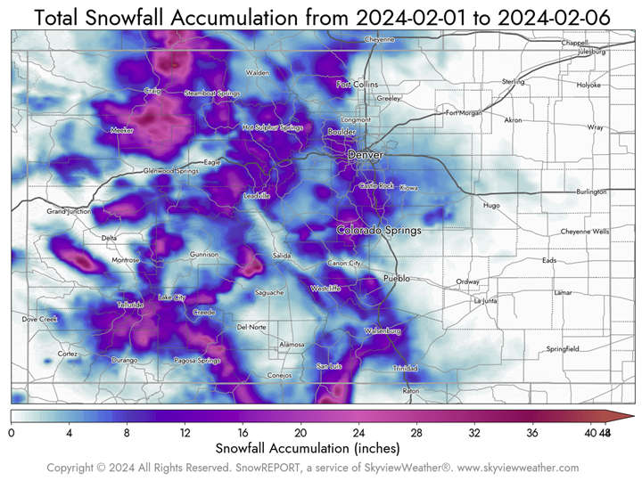
Meteorological forecasts predict the arrival of additional winter storms during the second week of the month. These storms are expected to augment the current snowfall totals for February and may contribute to the alleviation of the prevailing drought conditions across the state. To date, Denver International Airport (DIA) has reported 0.76” of liquid precipitation, surpassing the monthly average by 0.69”. Furthermore, DIA has already recorded 5.5” of snowfall within the initial days of February.
.
Denver’s Monthly Temperature, Rainfall, And Snowfall Extremes For February (1872-Present)
Top 20 Warmest February’s
| Rank | Avg | Year |
| 1 | 43.7 | 1954 |
| 2 | 42.3 | 1930 |
| 3 | 41 | 1925 |
| 4 | 40.7 | 1957 |
| 5 | 40.5 | 1943 |
| 6 | 40.3 | 2017 |
| 7 | 40.3 | 1991 |
| 8 | 40.3 | 1907 |
| 9 | 40.1 | 1992 |
| 10 | 40.1 | 1904 |
| 11 | 39.8 | 1932 |
| 12 | 39.3 | 1976 |
| 13 | 39.1 | 2000 |
| 14 | 39.1 | 1888 |
| 15 | 39.1 | 1886 |
| 16 | 39 | 1926 |
| 17 | 38.8 | 1931 |
| 18 | 38.6 | 1999 |
| 19 | 38.6 | 1950 |
| 20 | 38.5 | 1995 |
Top 20 Wettest February’s
| Rank | Total | Year |
| 1 | 2.01 | 1934 |
| 2 | 1.66 | 1960 |
| 3 | 1.44 | 1942 |
| 4 | 1.39 | 1953 |
| 5 | 1.35 | 1909 |
| 6 | 1.34 | 1912 |
| 7 | 1.31 | 1959 |
| 8 | 1.28 | 1966 |
| 9 | 1.28 | 1939 |
| 10 | 1.27 | 1965 |
| 11 | 1.25 | 2015 |
| 12 | 1.24 | 1915 |
| 13 | 1.22 | 1881 |
| 14 | 1.21 | 1987 |
| 15 | 1.11 | 1931 |
| 16 | 1.09 | 1923 |
| 17 | 1.05 | 1993 |
| 18 | 1.05 | 1962 |
| 19 | 1.04 | 1964 |
| 20 | 1.02 | 1918 |
Top 20 Snowiest February’s
| Rank | Total | Year |
| 1 | 22.4 | 2015 |
| 2 | 22.1 | 1912 |
| 3 | 20.2 | 2012 |
| 4 | 19.5 | 1942 |
| 5 | 18.3 | 1960 |
| 6 | 18.3 | 1909 |
| 7 | 18 | 1931 |
| 8 | 17.5 | 1959 |
| 9 | 17.1 | 1965 |
| 10 | 16.9 | 1993 |
| 11 | 16.5 | 2020 |
| 12 | 16.5 | 1953 |
| 13 | 16.3 | 1939 |
| 14 | 15.8 | 2022 |
| 15 | 15.7 | 1913 |
| 16 | 15.6 | 1934 |
| 17 | 15.2 | 1929 |
| 18 | 14.6 | 1966 |
| 19 | 14.1 | 2013 |
| 20 | 14 | 1915 |
Top 20 Coldest February’s
| Rank | Avg | Year |
| 1 | 17.7 | 1899 |
| 2 | 21.8 | 1913 |
| 3 | 22.2 | 1883 |
| 4 | 22.3 | 1989 |
| 5 | 22.7 | 1903 |
| 6 | 23.6 | 1929 |
| 7 | 24.1 | 1942 |
| 8 | 24.8 | 1960 |
| 9 | 24.9 | 1894 |
| 10 | 25.2 | 1905 |
| 11 | 25.4 | 2021 |
| 12 | 25.6 | 1874 |
| 13 | 25.8 | 1939 |
| 14 | 26.6 | 1895 |
| 15 | 26.7 | 1891 |
| 16 | 26.9 | 1936 |
| 17 | 27.1 | 1955 |
| 18 | 27.3 | 1964 |
| 19 | 27.4 | 1965 |
| 20 | 27.6 | 2003 |
Top 20 Driest February’s
| Rank | Total | Year |
| 1 | 0.01 | 1883 |
| 2 | 0.02 | 1877 |
| 3 | 0.03 | 1891 |
| 4 | 0.04 | 1949 |
| 5 | 0.04 | 1948 |
| 6 | 0.04 | 1962 |
| 7 | 0.04 | 1973 |
| 8 | 0.06 | 1959 |
| 9 | 0.06 | 1992 |
| 10 | 0.07 | 1989 |
| 11 | 0.08 | 1974 |
| 12 | 0.09 | 1965 |
| 13 | 0.09 | 1944 |
| 14 | 0.09 | 1905 |
| 15 | 0.1 | 2014 |
| 16 | 0.1 | 1967 |
| 17 | 0.11 | 1874 |
| 18 | 0.15 | 1951 |
| 19 | 0.15 | 2001 |
| 20 | 0.15 | 1940 |
Top 20 Least Snowiest February’s
| Rank | Total | Year |
| 1 | T | 2009 |
| 2 | 0.3 | 1992 |
| 3 | 0.3 | 1970 |
| 4 | 0.5 | 2005 |
| 5 | 0.6 | 1954 |
| 6 | 0.6 | 1925 |
| 7 | 0.8 | 1991 |
| 8 | 0.8 | 1983 |
| 9 | 1 | 1943 |
| 10 | 1.1 | 1908 |
| 11 | 1.1 | 1906 |
| 12 | 1.3 | 1999 |
| 13 | 1.5 | 1949 |
| 14 | 1.6 | 2017 |
| 15 | 1.6 | 1957 |
| 16 | 1.8 | 2000 |
| 17 | 1.8 | 1982 |
| 18 | 1.9 | 1916 |
| 19 | 2 | 1882 |
| 20 | 2.1 | 1963 |
February Climatology for Denver
(Normal Period 1991-2020 Dia Data)
Temperature
| Temperature | Observed Value |
| Average High | 45.7°F |
| Average Low | 19.7°F |
| Monthly Mean | 32.7°F |
| Days With High 90 Or Above | 0 |
| Days With High 32 Or Below | 5.3 |
| Days With Low 32 Or Below | 26 |
| Days With Lows Zero Or Below | 1.6 |
Precipitation
| Precipitation | Observed Value |
| Monthly Mean | 0.41” |
| Days With Measurable Precipitation | 5.5 |
| Average Snowfall In Inches | 7.6” |
| Days With 1.0 Inch Of Snow Or More | 4 |
Miscellaneous Averages
| Miscellaneous Averages | |
| Heating Degree Days | 1000 |
| Cooling Degree Days | 0 |
| Wind Speed (Mph) | 9.7 mph |
| Wind Direction | North |
| Days With Thunderstorms | 0 |
| Days With Dense Fog | 2 |
| Percent Of Sunshine Possible | 61% |
Extremes
| Extremes | |
| Record High | 80 on 2/10/2017 |
| Record Low | -25 on 2/1/1951, 2/8/1936 |
| Warmest | 43.7 in 1954 |
| Coldest | 17.7 in 1899 |
| Wettest | 2.01” in 1934 |
| Driest | 0.01” in 1883 |
| Snowiest | 22.4” in 2015 |
| Least Snowy | TR in 2009 |
Winter 2023/2024 Snowfall Accumulation for the Colorado Eastern Plains
| City | Oct | Nov | Dec | Jan | Feb | Mar | Apr | Total |
| Aurora | 6.6 | 2.3 | 10.4 | 3.9 | 23.2 | |||
| Boulder | 5 | 7.8 | 9.2 | 8.5 | 30.5 | |||
| Brighton | 4.7 | 4 | 1.1 | 2.2 | 12 | |||
| Broomfield | 4.3 | 5.3 | 3.2 | 5.1 | 17.9 | |||
| Castle Rock | 9 | 2.1 | 9.7 | 12.1 | 32.9 | |||
| Colorado Springs Airport | 0 | 1.1 | 8.4 | 5.1 | 14.6 | |||
| Denver DIA | 7.5 | 2.9 | 1.4 | 4.2 | 16 | |||
| Denver Downtown | 5.3 | 2.1 | 6.2 | 4.6 | 18.2 | |||
| Golden | 10.7 | 14 | 14.6 | 13.2 | 52.5 | |||
| Fort Collins | 5.7 | 9.6 | 0 | 3.3 | 18.6 | |||
| Highlands Ranch | 5.8 | 1.8 | 6.9 | 5.1 | 19.6 | |||
| Lakewood | 8.6 | 4.1 | 11.3 | 5.5 | 29.5 | |||
| Littleton | 10 | 1.6 | 6 | 3.7 | 21.3 | |||
| Monument | 6.5 | 1.5 | 14.8 | 14.1 | 36.9 | |||
| Parker | 7.4 | 1 | 8.8 | 9.1 | 26.3 | |||
| Sedalia – Hwy 67 | 10.5 | 3.3 | 9.4 | 12.8 | 36 | |||
| Thornton | 4 | 4.4 | 4.4 | 4.4 | 17.2 | |||
| Westminster | 5.1 | 4.7 | 5.3 | 4.8 | 19.9 | |||
| Wheat Ridge | 6 | 3.4 | 6.9 | 5.3 | 21.6 | |||
| Windsor | 3.5 | 5.5 | TR | 4.9 | 13.9 |
The Skyview Weather Newsletter is a monthly publication that aims to provide readers with engaging and informative content about meteorological science. Each issue features articles thoughtfully composed by Skyview’s team of meteorologists, covering a wide range of topics from the birth of Doppler Radar to the impact of weather phenomena. The newsletter serves as a platform to share the latest advancements in weather forecasting technology and the science behind it, enhancing our understanding of weather.
Skyview Weather has been a pillar for reliable weather services for over 30 years, providing unparalleled forecasts and operations across the Continental US. We offer a comprehensive suite of services that range from live weather support to detailed forecasts, extensive weather data collection, and weather reporting. Our clients, ranging from concert venues to golf courses, theme parks to hotels, schools to police departments, and more, rely on Skyview Weather for winter and summer weather alerts, now available on the Skyview Weather mobile app. These alerts cover a broad spectrum of weather conditions, including snow, lightning, hail, tornadoes, severe weather, and heavy rain. Learn more about how Skyview Weather products and services can support your organization through severe, winter, flood, and fire weather.