October 2024 Skyview Weather Monthly Newsletter
Feature Article
NWS Watch, Warning, and Advisory Review
This list has the watch, warning, and advisory criteria for Colorado along and east of the Continental Divide. Heavy snow criteria for eastern and central Colorado are representative values applied over a large geographic area.
Lower elevations – 6 inches of snow in 12 hours, 8 or more inches in 24 hours
Mountains – 8 inches of snow in 12 hours, 12 or more inches in 24 hours
Winter Watches and Warnings
A winter storm watch is issued when winter storm conditions are possible within the next 3 days, but the timing, intensity, or occurrence may still be uncertain.
A winter storm warning is issued when heavy snow is occurring or will develop in the next 36 hours. The heavy snow may be accompanied by wind greater than 15 mph and blowing snow.
A blizzard watch is issued when blizzard conditions are possible in the next 12 to 36 hours.
A blizzard warning is issued in lower elevations when the following conditions are expected for at least 3 hours:
- sustained winds of 35 mph or greater.
- considerable falling and or drifting snow lowering.
- visibilities less than 1/4 mile.
A blizzard warning is issued in the mountains and foothills for the conditions above, but with winds more than 50 mph at the higher elevations.
A wind chill watch is issued when wind chill warning criteria are possible in the next 12 to 36 hours.
A wind chill warning is issued for wind chills of at least minus 25 degrees on the plains, and minus 35 degrees in the mountains and foothills.
A freeze watch is issued when freezing conditions are possible in the next 12 to 36 hours.
A freeze warning is issued during the growing season when widespread temperatures are expected to drop to below 32 degrees.
A high wind watch is issued when high wind conditions are expected to develop in the next 12 to 36 hours. Sometimes it will be issued late in the first forecast period, 6 to 12 hours, if the potential for high wind exists.
A high wind warning is issued for the following conditions:
- Mountains, Foothills, and nearby adjacent plains including Fort Collins, Boulder, and western Denver suburbs – sustained winds of 50 mph for at least 1 hour or gusts to 75 mph for any duration in the mountains and foothills.
- Lower Elevations away from the foothills – sustained winds of 40 mph for at least 1 hour, or gusts to 58 mph for any duration at lower elevations away from the foothills.
A snow squall warning is issued when a brief but heavy band of snow develops. Snow squalls are often associated with stronger cold fronts and are a key wintertime weather hazard. They generally move in and out quickly, typically lasting less than an hour. They bring sudden white-out conditions combined with falling temperatures that produce icy roads in just a few minutes. Snow squalls can occur where there is no large-scale winter storm in progress and might only produce minor accumulations. Some snow squalls can cause localized tough travel conditions for the public and to commerce for brief periods of time. Unfortunately, there is history of deadly traffic accidents associated with snow squalls. Although snow accumulations are typically an inch or less, the added combination of gusty winds, falling temperatures and quick reductions in visibility can cause extremely dangerous conditions for motorists.
Advisories
A winter weather advisory is issued when:
- general snow accumulations are expected to be between 4 and 8 inches in 12 hours in the mountains and foothills, and between 3 and 6 inches in 12 hours at lower elevations.
- When falling snow is accompanied by blowing snow to cause travel problems due to lower visibilities.
- When wind-blown snow will occasionally reduce visibilities and create a hazard for travelers.
- For freezing drizzle or a mix of precipitation types, such as snow and sleet, that will impact travel conditions.
A dense fog advisory is issued when fog reduces visibilities to 1/4 mile or less.
A wind chill advisory is issued on the plains when wind and temperature combine to produce wind chill values of minus 18 degrees to minus 25 degrees.
A wind chill advisory is issued for the mountains and foothills when wind and temperature combine to produce wind chill values of minus 25 degrees.
A frost advisory is issued during the growing season when temperatures are expected to drop to between 32 and 35 degrees on clear calm nights.
A blowing dust advisory is issued when blowing dust reduces visibilities to between a quarter of a mile and a mile.
Colorado Drought Update

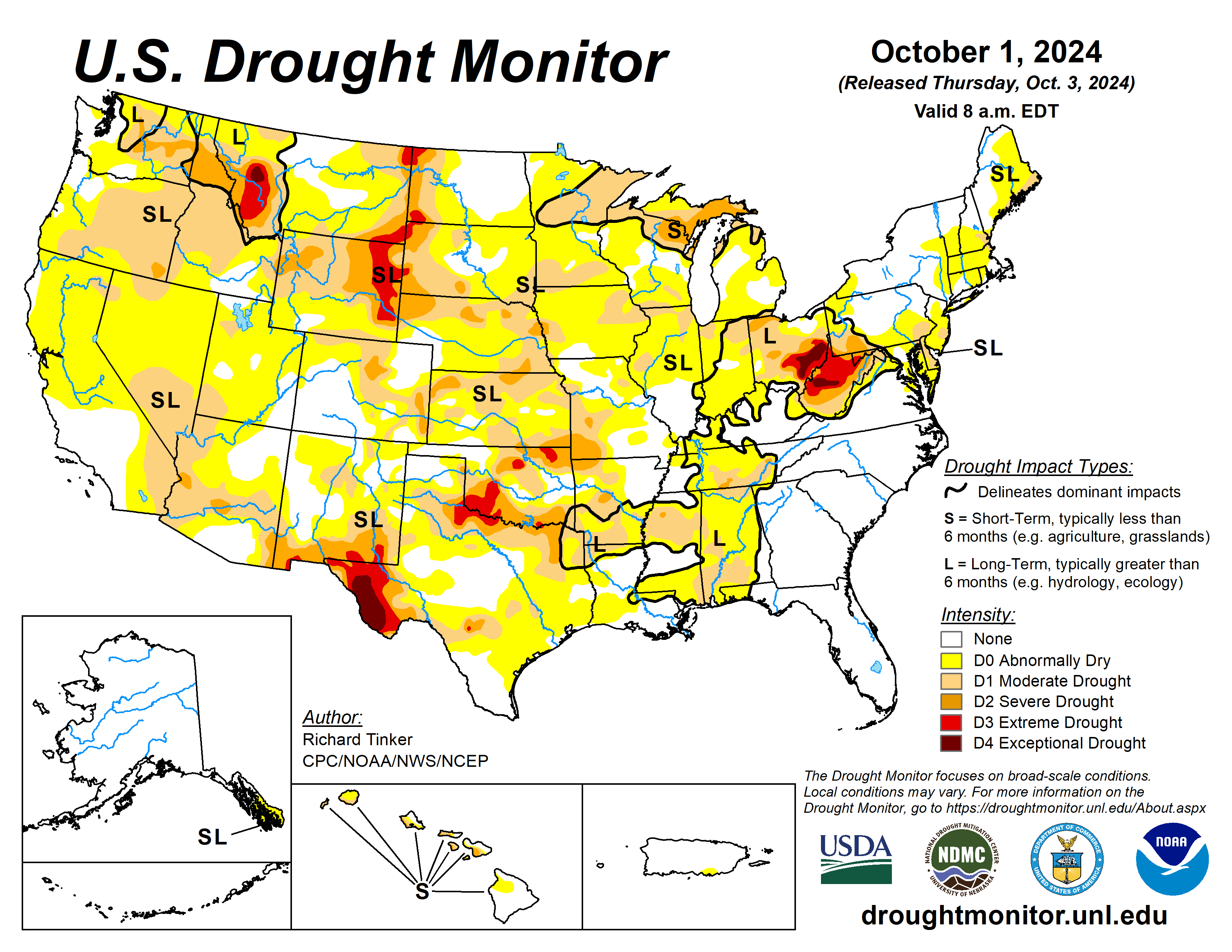
With another relatively dry month across Colorado during September, drought conditions have remained elevated for portions of the state. The driest area is still centered around the Denver Metro where we continued to be under a Severe Drought at this time. Southeastern portions of the state have also been dryer than usual, increasing the drought conditions in that area as well. Better moisture for wester/southwestern portions of the state have helped drought conditions in those areas where currently no drought conditions exist. Similar for northeastern portions of the state and along the I-76 corridor.
October 2024 Temperature Anomaly Forecast

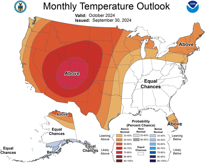
Well above average temperatures are expected for the month of October, typical of a strong La Niña event for the Colorado region. So far in the first week of the month, a couple of days have reached record breaking temperatures for the Denver area. Above average temperatures are expected to continue throughout most of the month as high-pressure looks to dominate the region during the month.
October 2024 Precipitation Anomaly Forecast

Along with well above average temperatures, well below average precipitation is expected for much of the United States and especially for the Colorado region. Once again, this is typical for a strong La Niña event as Colorado heads deeper into the Fall season. Very little precipitation so far this month with very little precipitation expected over the next week.
Weather Summary for Colorado, September 2024
High-pressure dominated much of the Colorado region throughout the month of September resulting in above average temperatures with below average precipitation for the month. This was typical of the summer into fall season as this was the 4th consecutive month with above average temperatures for the Denver area. The warmest time of the month was in the first half where 7 of the 9 days at or above 90°F occurred. During this time, minimal rainfall events occurred with just 2 days of rain recorded for Denver Internation Airport (DIA), both the 4th and the 5th with a combined 0.30” of precipitation during that time.
The most impactful precipitation event occurred during the 21st and into the 22nd where 0.94” of rain fell, 0.12” on 9/21 and 0.82” on 9/22. This single event helped the region remain above average precipitation wise with some areas receiving well over an inch during this event. Total precipitation for DIA during the month of September was 1.24”. Dry conditions would take hold for the remainder of the month with no additional precipitation for the Denver Metro area and most of northern Colorado as well.
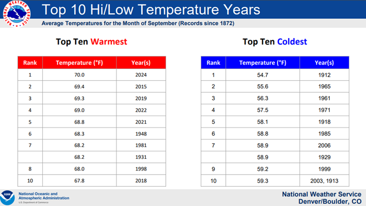
Temperatures would also be above average through the rest of the month. Most days would typically be 5-10°F above the normal daily temperatures for that time of year. This would make September of 2024 the warmest on record since 1872! Below is a list of top ten warmest and coldest Septembers for DIA from the National Weather Service:

Colorado Springs had a September average temperature of 66.4°F. This was 3.4°F above the normal and made September of 2024 the 8th warmest September on record for Colorado Springs. The warmest September remains 2019 when the average monthly temperature was 68.7°F. The average September high temperature in Colorado Springs was 81.7°F, 4.6°F degrees above normal. The average September low temperature in Colorado Springs was 51.0°F, which is 2.1°F above normal.
Colorado Springs recorded 0.87” of precipitation during the month of September, which is 0.48” below the normal of 1.35”. Colorado Springs had no snow through the month of September, which is 0.2” below the typical normal. Colorado Springs set 2 daily record high temperatures and 1 daily record high minimum temperature during the month of September. The most meaningful record high temperature of 91°F occurred on September 30th. This also became the latest date of seeing 90+ degree temperatures in Colorado Springs, surpassing the 91 degrees set on September 25th, 2020.
The average temperature in Pueblo for the month of September was 69.2°F. This was 2.6°F degrees above normal and made September of 2024 only the 15th warmest September on record. This remains well behind the warmest September which occurred in 2019 when the average monthly temperature was 72.8°F. The average September high temperature in Pueblo was 87.3°F, 4.2°F degrees above normal of 83.1°F. The average September low temperature in Pueblo was 51.2°F, which is 1.1°F above the normal of 50.1°F. Pueblo recorded 0.67” of precipitation throughout the month of September, only 0.02” above normal of 0.65”. The highest temperature was on the 26th where it reached 97°F in Pueblo.
Weather Statistics for Denver International Airport (DIA), September 2024
DIA Temperature (°F), September 2024
| TEMPERATURE (IN DEGREES F) | OBSERVED VALUE | NORMAL VALUE | DEPARTURE FROM NORMAL | |
| AVERAGE MAX | 85.5°F | 79.6°F | 5.9°F | |
| AVERAGE MIN | 54.5°F | 50.0°F | 4.5°F | |
| MONTHLY MEAN | 70.0°F | 64.8°F | 5.2°F | |
| DAYS WITH MAX 90 OR ABOVE | 9 | 4.2 | 4.8 | |
| DAYS WITH MAX 32 OR BELOW | 0 | 0.0 | 0.0 | |
| DAYS WITH MIN 32 OR BELOW | 0 | 0.7 | -0.7 | |
| DAYS WITH MIN 0 OR BELOW | 0 | 0.0 | 0.0 | |
| OBSERVED VALUE | DATE | NORMAL VALUE | DEPARTURE FROM NORMAL | |
| HIGHEST | 94°F | 9/3 | ||
| LOWEST | 44°F | 9/19 | ||
DIA Liquid Precipitation (Inches), September 2024
| PRECIPITATION (IN INCHES) | ||||
| MONTHLY TOTAL | 1.24” | 1.35” | -0.11” | |
| YEARLY TOTAL | 12.87” | 12.24” | 0.63” | |
| GREATEST IN 24 HOURS | 0.94” | 9/21~9/22 | ||
| DAYS WITH MEASURABLE PRECIP. | 4 | 6 | -2 |
2024 Rainfall Accumulation for the Colorado Eastern Plains
| City | May | June | July | Aug | Sept | Total |
| Aurora (Central) | 1.17 | 0.29 | 0.74 | 0.61 | 1.13 | 3.94 |
| Boulder | 0.26 | 0.35 | 0.50 | 1.32 | 1.35 | 3.78 |
| Brighton | 0.57 | 0.41 | 1.04 | 1.30 | 1.18 | 4.50 |
| Broomfield | 0.77 | 0.35 | 0.94 | 1.07 | 1.31 | 4.44 |
| Castle Rock | 1.59 | 1.65 | 2.28 | 2.78 | 0.77 | 9.07 |
| Colorado Springs Airport | 0.82 | 0.51 | 2.06 | 3.29 | 0.87 | 7.55 |
| Denver DIA | 1.70 | 0.36 | 1.10 | 0.92 | 1.24 | 5.32 |
| Denver Downtown | 1.21 | 0.07 | 2.05 | 0.71 | 1.21 | 5.25 |
| Golden | 0.98 | 0.58 | 0.91 | 2.48 | 1.65 | 6.60 |
| Fort Collins | 0.93 | 0.51 | 1.34 | 1.51 | 0.39 | 4.68 |
| Highlands Ranch | 1.81 | 0.52 | 0.74 | 1.74 | 1.34 | 6.15 |
| Lakewood | 1.03 | 0.74 | 1.26 | 1.85 | 1.47 | 6.35 |
| Littleton | 1.39 | 0.38 | 0.50 | 1.00 | 1.16 | 4.43 |
| Monument | 1.79 | 0.50 | 2.01 | 1.03 | 1.05 | 6.38 |
| Parker | 1.63 | 1.01 | 1.10 | 2.72 | 1.04 | 7.50 |
| Sedalia – Hwy 67 | 1.94 | 1.03 | 0.94 | 1.89 | 0.69 | 6.49 |
| Thornton | 0.37 | 0.28 | 1.20 | 0.94 | 1.28 | 4.07 |
| Westminster | 0.65 | 0.47 | 0.91 | 0.94 | 1.68 | 4.65 |
| Wheat Ridge | 0.75 | 0.42 | 0.98 | 0.72 | 1.54 | 4.41 |
| Windsor | 0.94 | 1.36 | 0.93 | 2.11 | 1.15 | 6.49 |
October 2024 Preview
October’s weather usually begins to stabilize for the Denver Metro area as cooler, dry airmasses from the northern plains and Canadian region begin to consistently work their way into the central and high plains of eastern Colorado. Temperature spreads can widen even further as the warmer months truly end. October is also usually when Colorado receives the first snowfall, specifically around October 16th. Average temperatures continue their downward trend during the month of October with the average high temperature being 65.9°F, with an average of <0.1 days exceeding 90 degrees during the month. October is climatologically the 5th warmest month of the year for Denver.
Average precipitation during the month of October is 1.02”. So far this month, there has yet to have been any precipitation as of the 6th, but given the current precipitation outlook, there should be some rainfall and possibly some snow for areas above 7.5k ft during the second weekend this month. Temperature-wise, October starts off warm with highs in the 70s, but will gradually get cooler as the month progresses, with daily high temperatures dropping into the 50s by late October. Overall, above-normal temperatures are likely for most areas in October this year, as well as below-normal precipitation as high-pressure looks to remain in place for extended periods.
Similar conditions for southeastern portions of the state. Generally, areas south of the Palmer Divide stay relatively warmer, resulting in less chances for impactful snow during the month. This has been the case for the early portions of October as well above seasonal averages have resulted in warm conditions for Colorado Springs to Pueblo. As the month progresses, temperatures tend to trend downward with the first freeze typically by the end of the month for both Colorado Springs and southward into Pueblo.
October Climatology for Denver
(Normal Period 1991-2020 Dia Data)
Temperature
| AVERAGE HIGH | 65.9°F |
| AVERAGE LOW | 36.6°F |
| MONTHLY MEAN | 50.9°F |
| DAYS WITH HIGH 90 OR ABOVE | <0.1 |
| DAYS WITH HIGH 32 OR BELOW | 0.4 |
| DAYS WITH LOW 32 OR BELOW | 8.5 |
| DAYS WITH LOWS ZERO OR BELOW | <0.1 |
Precipitation
| MONTHLY MEAN | 1.02” |
| DAYS WITH MEASURABLE PRECIPITATION | 5.3 |
| AVERAGE SNOWFALL IN INCHES | 4.0” |
| DAYS WITH 1.0 INCH OF SNOW OR MORE | 3.9 |
Miscellaneous Averages
| HEATING DEGREE DAYS | 440 |
| COOLING DEGREE DAYS | 5 |
| WIND SPEED (MPH) | 7.8 mph |
| WIND DIRECTION | South |
| DAYS WITH THUNDERSTORMS | 0.8 |
| DAYS WITH DENSE FOG | 0.6 |
| PERCENT OF SUNSHINE POSSIBLE | 72% |
Extremes
| RECORD HIGH | 90 on 10/1/1892 |
| RECORD LOW | -2 on 10/29/1917 |
| WARMEST | 59.9 in 1950 |
| COLDEST | 39.0 in 1969 |
| WETTEST | 4.17” in 1969 |
| DRIEST | TR in 1934 |
| SNOWIEST | 31.2” in 1969 |
| LEAST SNOWY | 0.0” |
The Skyview Weather Newsletter is a monthly publication that aims to provide readers with engaging and informative content about meteorological science. Each issue features articles thoughtfully composed by Skyview’s team of meteorologists, covering a wide range of topics from the birth of Doppler Radar to the impact of weather phenomena. The newsletter serves as a platform to share the latest advancements in weather forecasting technology and the science behind it, enhancing our understanding of weather.
Skyview Weather has been a pillar for reliable weather services for over 30 years, providing unparalleled forecasts and operations across the Continental US. We offer a comprehensive suite of services that range from live weather support to detailed forecasts, extensive weather data collection, and weather reporting. Our clients, ranging from concert venues to golf courses, theme parks to hotels, schools to police departments, and more, rely on Skyview Weather for winter and summer weather alerts, now available on the Skyview Weather mobile app. These alerts cover a broad spectrum of weather conditions, including snow, lightning, hail, tornadoes, severe weather, and heavy rain. Learn more about how Skyview Weather products and services can support your organization through severe, winter, flood, and fire weather.
