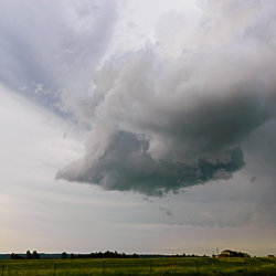
Dry Thunderstorms
In the state of Colorado, not all thunderstorms result in measurable precipitation. The criteria for a weather event to be classified as a thunderstorm are the presence of both lightning and thunder. There are numerous instances along Colorado’s Front Range where atmospheric moisture is limited, yet there is sufficient instability to generate high-based thunderstorms.
A “high-based” thunderstorm refers to a scenario where the base of the cloud forms significantly above the surface, typically at elevations of 8,000 feet or more. The larger the distance from the base of the cloud to the ground, the greater the evaporation of rainfall before it reaches the surface. In many cases, no rainfall reaches the ground at all. This phenomenon is known as virga, and it is common across dry climates such as the High Plains of Colorado.
The period from late June to mid or late July is one of the most common times for “dry thunderstorms” to occur. This is primarily due to seasonal changes, as the cooler temperatures of spring give way to the heat of summer, but the monsoonal moisture from the desert southwest has not yet arrived. As deeper moisture arrives later in the season, the likelihood of dry thunderstorms decreases through August until the transition into fall. As monsoon moisture leaves the state, dry thunderstorms are likely to occur again by early to mid-September.

The concept of temperature and dew point spreads is often discussed in meteorological contexts as the “dewpoint depression”. The dewpoint depression refers to the difference between the air temperature and the dew point at the surface, which serves as a good indicator of the potential for evaporation and the strength of potential wind gusts. At the base of a cloud, the temperature and dew point are identical, leading to condensation and cloud formation. However, at the surface, the temperature and dewpoint depression can be as much as 50 to 60 degrees.
For instance, if the air temperature outside is 90 degrees and the current dew point is 30 degrees, the dewpoint depression is 60 degrees. The dewpoint depression can be used to predict potential wind speeds or gusts from thunderstorms; in this case, a 60-mph wind gust is highly likely. These wind gusts are caused by the downburst process; air beneath a thunderstorm cools as a result of rainfall evaporating before it reaches the ground. Because cool air is generally more dense than warm air, this cooler air rushes to the surface and spreads outwards from a central point. These winds, known as outflow boundaries, can travel quite a long distance, gradually weakening further away from the central point.
Outflow boundaries can collide against the foothills or with another outflow boundary from a different storm, triggering new thunderstorm development. Often, these outflow boundary-driven storms are referred to as “popcorn” type thunderstorms, as they frequently strengthen and weaken rapidly. Outflow boundaries and their associated winds can often catch people off guard, manifesting as a sudden gust of wind during outdoor activities.
For additional information on dry thunderstorms, please refer to the National Severe Storms Laboratory learning pages: https://www.nssl.noaa.gov/education/svrwx101/thunderstorms/types/
If you liked this article, check out Skyview Weather’s growing library of educational weather and climate content. Skyview Weather also offers comprehensive in-person and virtual weather education and weather safety training classes to ensure you and your staff are informed and prepared for severe, winter, and fire weather.
