The first week of February brought a deluge of precipitation to the Denver Metro Area, leaving residents grappling with heavy snowfall and rain. From February 2nd to the 3rd, a formidable storm system swept through the region, defying the typical characteristics of a February storm and adopting a ‘spring-like’ demeanor. During this period, Denver International Airport (DIA) reported 0.76 inches of liquid precipitation, surpassing the monthly average by 0.69 inches. This puts February 3rd of 2024 as the wettest February day since 1962.
Storm Summary:
This anomalous storm system was characterized by rapidly evolving small-scale features, including low-level convergence and subtle temperature fluctuations, which significantly influenced the timing and intensity of snowfall across the Denver Metro Area.
By the afternoon of February 2nd, an upper-level trough propagated into the Four Corners region, ushering in moist southwesterly flow over the area. As evening descended, the low pressure system intensified and migrated over the Texas/Oklahoma panhandles, initiating precipitation in the form of rain across Denver.
As the upper-level low decelerated and stalled over the Texas/Oklahoma Panhandles, a transition from rain to snow occurred throughout the morning of February 3rd. Notably, a barrier jet formed along the I-25 corridor, contributing to localized heavy precipitation within the area. This phenomenon, coupled with enhanced low-level convergence induced by the collision of upslope flow from the east and down-sloping trending winds off the foothills, intensified snowfall rates of up to 1-2 inches per hour near the foothills.
As the barrier jet gradually moved westward throughout the afternoon, precipitation subsided for portions of the eastern metro area. However, snowfall persisted into the evening hours near the foothills before concluding late in the evening.
Snow Totals:
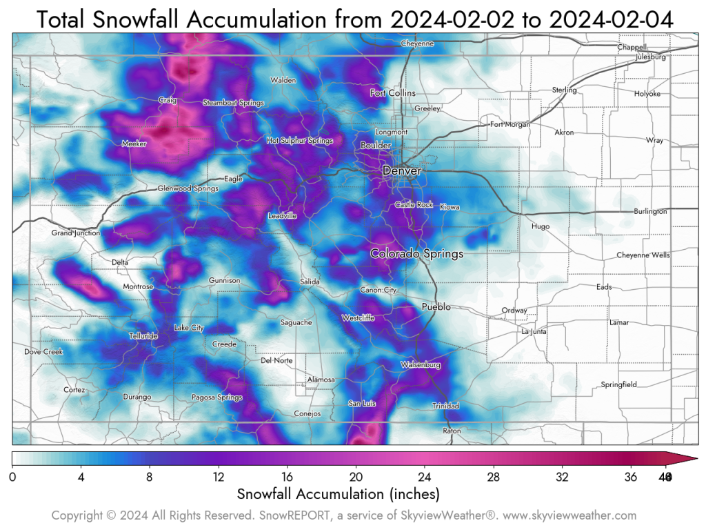
Areas along the foothills, including Lakewood, Littleton, and Boulder, recorded the highest snow accumulations, with reports exceeding 19.0 inches. A map of Colorado below showcases the spatial distribution of snowfall totals.
Barrier Jets:
The substantial snowfall experienced in portions of the metro area can largely be attributed to the formation of a barrier jet. According to the National Weather Service (NWS), a barrier jet is a jet-like wind current that forms when stably-stratified low-level airflow approaches a mountain barrier and deflects parallel to its longitudinal axis. In the context of Denver, this results in a northerly flow. The combination of upslope flow and diabatic heating from melting precipitation at the surface (which was occurring during this storm due to warmer surface temperatures melting snow on the ground) can enhance the acceleration of the jet.
From a forecasting standpoint, barrier jets significantly alter flow dynamics and thermodynamics, potentially leading to mesoscale overrunning of upstream low-level flow, cloud formation, and precipitation induction. Additionally, barrier jets may contain low-level cold advection, warm advection, or moisture advection, thereby influencing precipitation type and generating convective instability.
In conclusion, the interplay of meteorological factors, including the barrier jet phenomenon, contributed to the complexity and intensity of Denver’s recent snowstorm. Understanding these mechanisms enhances our ability to forecast and prepare for future weather events in the region.