
After a summer marked by heat and wildfire concerns, Colorado may have some encouraging weather ahead. The Climate Prediction Center (CPC) is favoring above-normal precipitation across much of Colorado this fall, including September, and a strengthening El Niño could help shape the weather pattern in the months ahead.
So, could Colorado get a nice bang to the end of monsoon season?
There are reasons to be optimistic.
A Wetter Fall Is Favored for Colorado
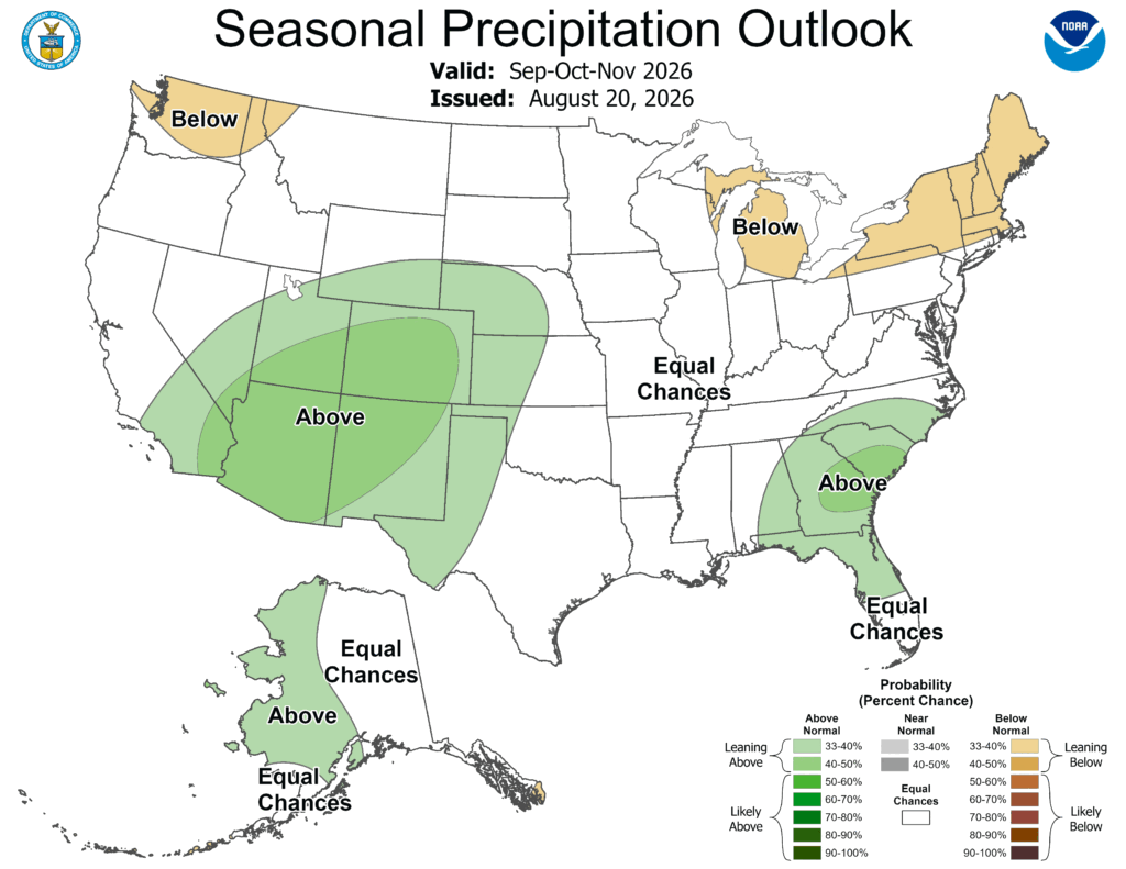
The CPC’s latest seasonal precipitation outlook, issued August 20, favors above-normal precipitation across much of the Southwest and southern Rockies for September through November.
Much of Colorado is shaded green on the outlook, indicating increased odds of precipitation finishing the three-month period above normal.
It’s important to remember that this is a seasonal probability forecast, not a prediction of how much rain Colorado will receive. It doesn’t mean every week will be wet or that thunderstorms will occur every afternoon.
But September is still part of Colorado’s transition out of the summer monsoon, so a favorable pattern could provide a few more opportunities for moisture and thunderstorms before the season fully winds down.
El Niño Is Strengthening
One of the biggest factors getting forecasters’ attention is developing in the tropical Pacific.
El Niño has strengthened significantly over the past month.
Sea-surface temperature anomalies in the eastern equatorial Pacific have climbed above +2°C, while July’s Niño-3.4 index reached +1.4°C. The Niño-1+2 region was even warmer, reaching +2.9°C.
The changes aren’t limited to the ocean’s surface, either. Subsurface temperatures have become significantly warmer than normal, with anomalies reaching as high as +10°C at depth. Atmospheric patterns have also shifted, including changes in winds and tropical rainfall that are consistent with a strengthening El Niño.
In other words, the ocean and atmosphere are increasingly behaving like a classic El Niño pattern.
This Could Be a Very Strong El Niño
The CPC expects El Niño to continue strengthening through the end of 2026.
There is now a greater than 90% chance of a very strong El Niño during the Northern Hemisphere fall and winter of 2026-27.
Even more notably, the CPC gives a 69% chance that the October-December period will feature a historic event, exceeding the strength of previous El Niños dating back to 1950 based on its Relative Oceanic Niño Index.
A stronger El Niño generally means the odds of seeing weather patterns associated with El Niño increase—but it does not guarantee a particular outcome for Colorado.
That’s an important distinction when looking at seasonal forecasts.
What Does El Niño Mean for Colorado?
El Niño can influence the position of the jet stream, storm tracks and the distribution of moisture across the United States. Historically, El Niño has often been associated with wetter conditions across parts of Colorado, particularly during the colder months.
However, El Niño isn’t the only player in Colorado’s weather.
The summer monsoon depends on several ingredients, including the position of the subtropical ridge, atmospheric moisture, upper-level winds and shorter-term weather patterns. That means a strengthening El Niño doesn’t automatically translate into a wet September.
Instead, it can help shift the larger-scale odds in a particular direction.
And right now, those odds are looking favorable for Colorado’s precipitation heading into fall.
Could the Monsoon Go Out With a Bang?
That’s where things get interesting.
September is typically when Colorado’s monsoon begins to lose its grip as the atmosphere transitions toward fall. Thunderstorms become less frequent, temperatures begin to cool and the large-scale circulation starts changing.
But the transition doesn’t happen overnight.
If moisture remains available and the atmospheric pattern lines up, Colorado can still see significant thunderstorm and rainfall events during September. A handful of widespread storms could make a meaningful difference in monthly precipitation totals.
That could be especially welcome after a summer when dry conditions and wildfire activity have been major concerns across the state.
Of course, rainfall isn’t an instant cure for wildfire conditions. Heavy thunderstorms can produce more runoff than beneficial soaking, and lightning can create new fire starts. Still, widespread rain can provide important benefits for soils, vegetation and water supplies.
The Bigger Story May Be Winter
While the possibility of a wetter September is interesting, the strengthening El Niño could become even more important later this year.
The CPC expects El Niño to remain strong into the fall and winter, with the possibility of a very strong event occurring. However, it’s far too early to say exactly what winter will look like, but the developing El Niño is a pattern worth watching closely.
Colorado’s Weather Pattern Is Changing
For now, the takeaway is fairly simple: Colorado has a favorable precipitation signal heading into fall, and a rapidly strengthening El Niño is adding another interesting piece to the puzzle.
The CPC’s September-through-November outlook favors above-normal precipitation across much of the state. That doesn’t guarantee a wet September, but it does suggest that the door is open for additional moisture as Colorado’s monsoon season winds down.
And if El Niño continues to strengthen as expected, the weather story won’t end when the monsoon does.
After a summer dominated by heat and wildfire concerns, a few more rounds of rain could be a welcome way to close out the season—and the developing El Niño could set the stage for an even more interesting fall and winter.