
After an exceptionally dry start to 2026, Colorado has finally seen a much wetter weather pattern over the past several weeks. Repeated rounds of rain, cooler temperatures, and cloudy days have helped improve conditions along parts of the Front Range and eastern Colorado.
However, the latest drought data shows that drought remains widespread — and in some areas, extreme.
Drought Still Covers All of Colorado
According to the May 19, 2026 U.S. Drought Monitor map, 100% of Colorado remains in at least “abnormally dry” conditions.
The map shows:
- 96.23% of the state is in moderate drought (D1) or worse
- 79.31% is in severe drought (D2) or worse
- 42.91% is in extreme drought (D3) or worse
- 9.51% remains in exceptional drought (D4)
The most intense drought conditions are centered across parts of western and central Colorado, where the map shows large areas shaded in dark red and maroon, representing extreme to exceptional drought.
Meanwhile, portions of eastern Colorado are seeing somewhat less severe conditions, with areas of moderate drought and abnormal dryness.

Denver Has Seen a Wetter Pattern Recently
Denver’s recent weather pattern has been noticeably cooler and wetter compared to earlier this year.
The climate report as of May 27th shows:
- Denver has recorded 1.53 inches of precipitation so far in May
- Normal precipitation for May through May 27 is 1.87 inches
- Denver remains 0.34 inches below normal for the month
- Since January 1, Denver has received 3.13 inches of precipitation, which is still 2.07 inches below normal for the year
So while Denver is still below average overall in 2026 precipitation, the recent stretch of rain has helped reduce the deficit.
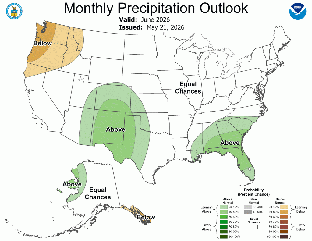
June Outlook Favors Wetter-Than-Average Conditions for Colorado
The NOAA Climate Prediction Center precipitation outlook for June 2026 actually leans wetter than average for at least parts of Colorado.
Parts of Colorado have an area of “Above” normal precipitation probabilities extending into southern and southeastern Colorado. Meanwhile, the rest of the state is largely in the “Slightly Above” category, meaning conditions are leaning wetter than normal.
That means:
- Southern Colorado has increased odds of above-average precipitation during June
- The remainder of Colorado could still see either wet or dry conditions, but is currently favoring wetter conditions
This outlook aligns well with Colorado’s transition into summer thunderstorm season, when afternoon and evening storms become more common across the state.
For drought-stricken areas — especially in southern Colorado — a wetter-than-average June would be welcome news if the forecast verifies. However, with drought conditions still severe across much of the state, sustained moisture over several months would still be needed for significant long-term improvement.
What This Means Going Forward
The recent rains have certainly helped parts of Colorado, especially along the urban corridor and eastern plains. Greener vegetation and improved surface moisture have been noticeable benefits of the wetter pattern.
But the drought monitor data shows Colorado still has substantial long-term moisture deficits, particularly in western parts of the state.
To significantly improve drought conditions statewide, Colorado would likely need:
- Continued regular precipitation through summer
- A healthy monsoon season
- Strong snowpack next winter
For now, recent storms have provided meaningful short-term relief, but the state is not out of drought yet.