Despite the recent cold snap in the past couple days, many Coloradans have recently enjoyed a taste of spring, with temperatures soaring into the upper 60s last week. These mild, sunny days have sparked a common question: what does the rest of March have in store for Colorado’s weather? Historically, March is known for delivering some of the state’s biggest snowstorms, but this year’s forecast presents an interesting mix of signals. Let’s take a closer look at the latest outlook from the Climate Prediction Center.
The Bigger Picture: What’s Influencing the Forecast?
Several large-scale atmospheric patterns are shaping the mid-to-late March forecast:
- Madden-Julian Oscillation (MJO): This tropical weather pattern is expected to move eastward through phases 2 and 3 in mid-March. While its influence on Colorado’s weather is indirect, it plays a role in overall atmospheric circulation.
- La Niña Influence: Although La Niña is weakening, its lingering effects continue to impact weather patterns, with outgoing longwave radiation anomalies reinforcing its presence.
- Stratospheric Polar Vortex: Currently strong, this system is forecast to weaken. However, since tropospheric responses lag behind, any impacts on Colorado’s weather may not be felt until late March or even April.
- Arctic Oscillation (AO) & Pacific-North American Pattern (PNA): A positive AO and negative PNA suggest a deep Arctic trough and mid-latitude ridging, which could lead to shifting storm tracks and temperature variations.
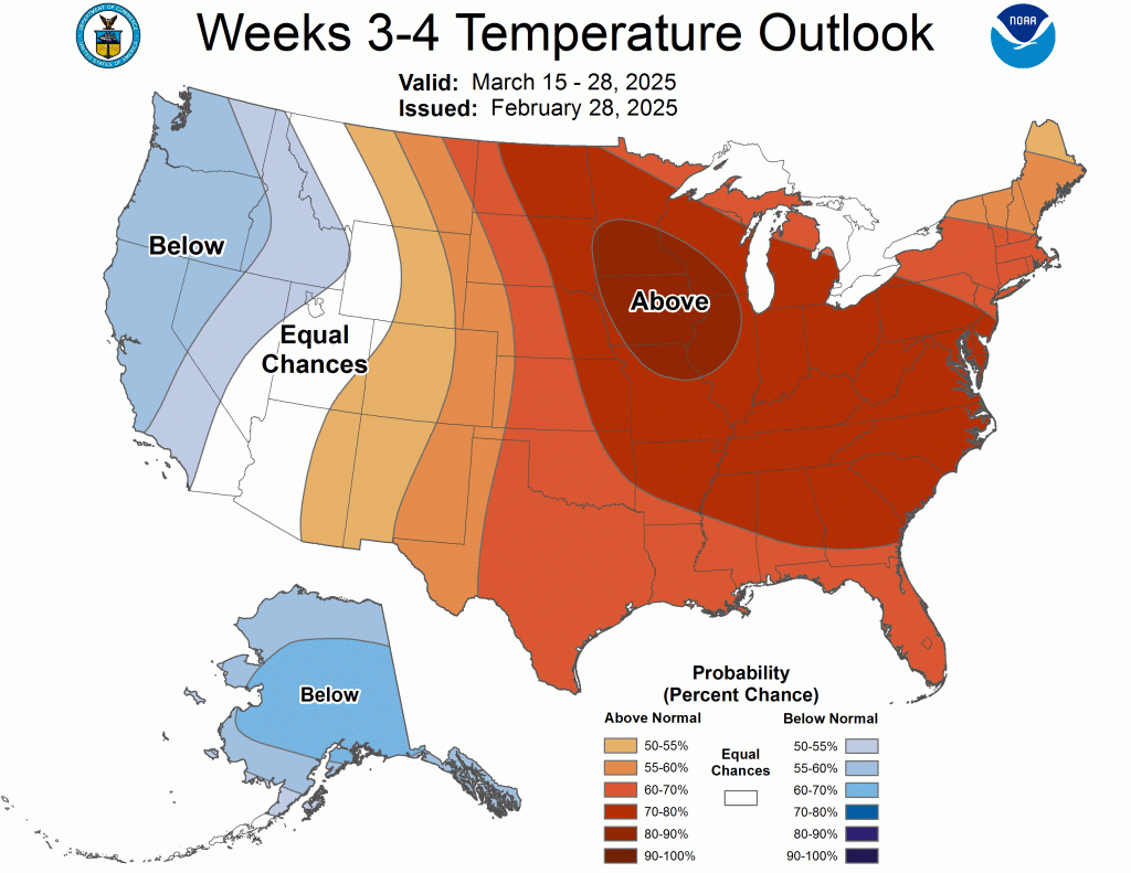
Temperature Outlook: Warmer Days Ahead?
According to the Climate Prediction Center, March 15-28 is expected to feature above-normal temperatures across most of the eastern two-thirds of the U.S. For Colorado, this means we’re more likely to see a continuation of those spring-like warm days. However, confidence decreases toward the western U.S., where the placement of upper-level ridges and troughs could impact temperature swings. While we may experience periodic warm-ups, it’s still too soon to rule out some late-season cold snaps.
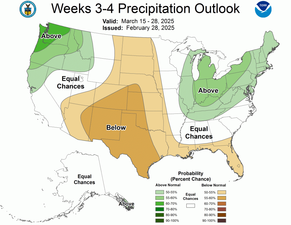
Precipitation Outlook: Drier Than Normal?
One of the biggest takeaways from the latest outlook is that Colorado may trend drier than normal in the coming weeks. A persistent ridge over the southwestern U.S. could lead to below-average precipitation across the Great Plains, including much of Colorado. This would suggest fewer opportunities for those classic March snowstorms. However, the Pacific Northwest is forecast to see an active storm track, which means any pattern shifts could still deliver moisture to the Rockies.
What Does This Mean for Colorado?
- More Mild Days: The forecast leans toward warmer-than-normal conditions, meaning we could see extended stretches of pleasant, spring-like weather.
- Lower Snow Chances: While March is historically snowy, current projections suggest fewer opportunities for big storms—though surprises can always happen.
- Uncertainty Remains: Weather patterns can shift, so it’s still important to stay updated on local forecasts, especially if you’re hoping for (or dreading) another round of snow.
Final Thoughts
Colorado’s weather is always unpredictable, but current signals point toward a milder and drier than normal second half of March. Whether you’re a fan of warm spring days or holding out hope for one last major snowstorm, it’s worth keeping an eye on how these evolving atmospheric patterns play out. Stay tuned, because in Colorado, the weather can change in an instant!