This November is shaping up to be an unusually active month across the U.S., with a potent combination of winter storms, severe thunderstorms, and a powerful hurricane stirring across the nation. Colorado faces one of the season’s strongest winter storms, while parts of Texas brace for severe weather, and the Gulf of Mexico contends with the remnants of Hurricane Rafael. These events mark an early start to high-impact weather, bringing significant disruptions across a wide swath of the country.
Winter’s Heavy Hand Over Colorado
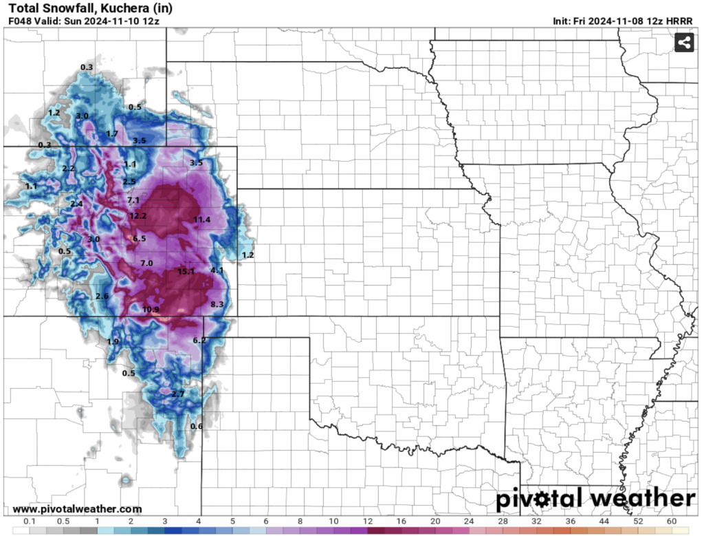
The Denver metro area and much of northeast and southern Colorado are grappling with one of the most intense winter storms in recent memory. Heavy snow is continuing today and is expected to finally subside by Saturday morning. Over the past three days, this storm has delivered impressive snowfall totals, with metro Denver receiving 10-15 inches and areas to the south and east potentially reaching up to 3 feet by the storm’s end. Winter Storm Warnings and advisories remain in effect across Colorado as road conditions worsen, travel grinds to a halt, and more snow is expected to blanket the region before the weekend.
Massive Snowfall Totals and Hazardous Driving Conditions
Moderate to heavy snowfall is occurring across northeast and north-central Colorado, with heavy snow bands expected to intensify this afternoon and evening. Interstate corridors, especially I-25 and I-70, are experiencing difficult travel conditions as snowfall rates peak. A brief midday lull in snow may offer limited relief, but snowfall is expected to intensify once again later in the afternoon. Winter Storm Warnings span the Urban Corridor and eastward into the plains, covering areas from Boulder to Douglas County and Lincoln County, where snow accumulations could exceed 3 feet in certain locations.
The Storm System’s Path and Impact
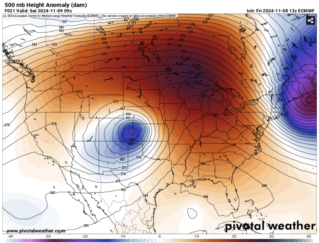
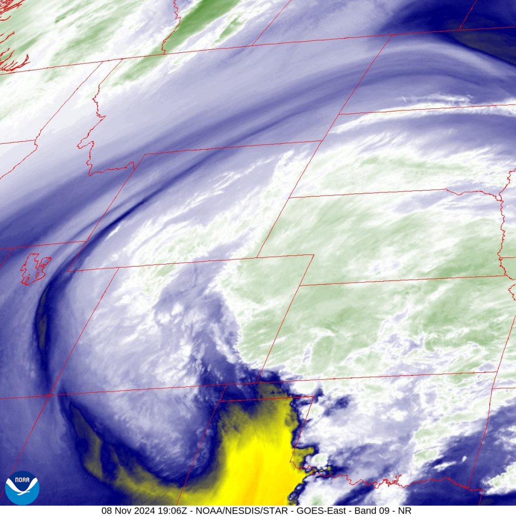
The powerful storm system currently sits over west-central New Mexico and is moving northeast, producing widespread precipitation across Colorado’s plains and mountainous regions. Heavy snowfall continues for the Raton Mesa and southern mountains, with totals expected to exceed a foot in certain areas this evening. A mix of rain and snow continues along the eastern plains, as warmer air circulates and creates a complex rain-snow line extending from Lamar and Springfield up into the Arkansas Valley. Cities like Pueblo and Colorado Springs have seen roads turn increasingly slick and slushy, with temperatures hovering around freezing.
Blizzard Conditions and Potential Travel Disruptions
Winds are expected to intensify along the plains near the Kansas border, potentially causing blowing and drifting snow across open areas. Though not a full blizzard, areas east of I-25, including Las Animas and Kiowa counties, may see periods of limited visibility and treacherous driving conditions due to gusts reaching 30 mph or more. Travelers are urged to stay off the roads if possible, as conditions will be particularly hazardous this evening.
Advice and Precautions for Colorado Residents
With significant snow accumulation across roads and continued heavy snowfall expected today, all Colorado residents, especially in the Denver and Pueblo regions, are advised to exercise caution if venturing out. Snow removal crews will be working around the clock to clear highways and streets, but hazardous road conditions are expected to persist through Saturday. Residents should also be mindful of potential ice build-up and ensure their homes are well-prepared for the prolonged period of cold and snow.
Severe Thunderstorms Add a Dangerous Twist Across Texas
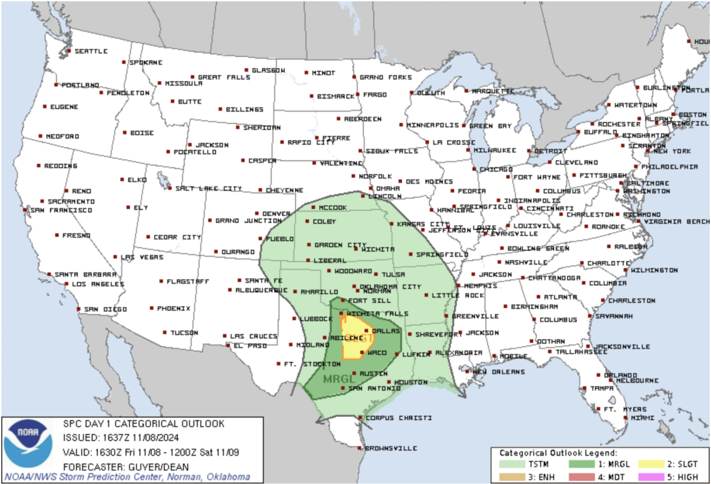
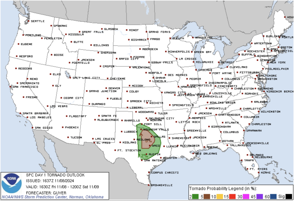
The same system affecting Colorado is creating favorable conditions for severe thunderstorms across Texas this afternoon and evening. The Storm Prediction Center (SPC) has issued a Slight Risk for Severe Thunderstorms for parts of North and Central Texas, including the Dallas-Fort Worth Metroplex. A combination of warm, humid air and instability in the atmosphere is setting up conditions for potentially dangerous weather.
Forecast for Severe Thunderstorm Development
Showers and thunderstorms are already forming across the warm sector ahead of a surface low-pressure area in the Low Rolling Plains. Surface dewpoints across North Texas are reaching the upper 60s to near 70°F, contributing to an unstable atmosphere. Forecasted instability of up to 1000 J/kg MLCAPE will likely support strong to severe thunderstorms, particularly along a warm front that may impact areas near the DFW Metroplex.
Tornado, Hail, and Wind Threats
Afternoon storms could become surface-based, allowing them to tap into unstable air and develop rotation. Isolated tornadoes, damaging winds, and large hail are all possible, particularly with discrete storms interacting with the warm front. The primary severe threat will span from North Texas into parts of Central and East Texas this afternoon through mid-evening. As the evening progresses, the storms are expected to weaken and move eastward, with the severe threat gradually diminishing.
Hurricane Rafael Looms Over the Gulf
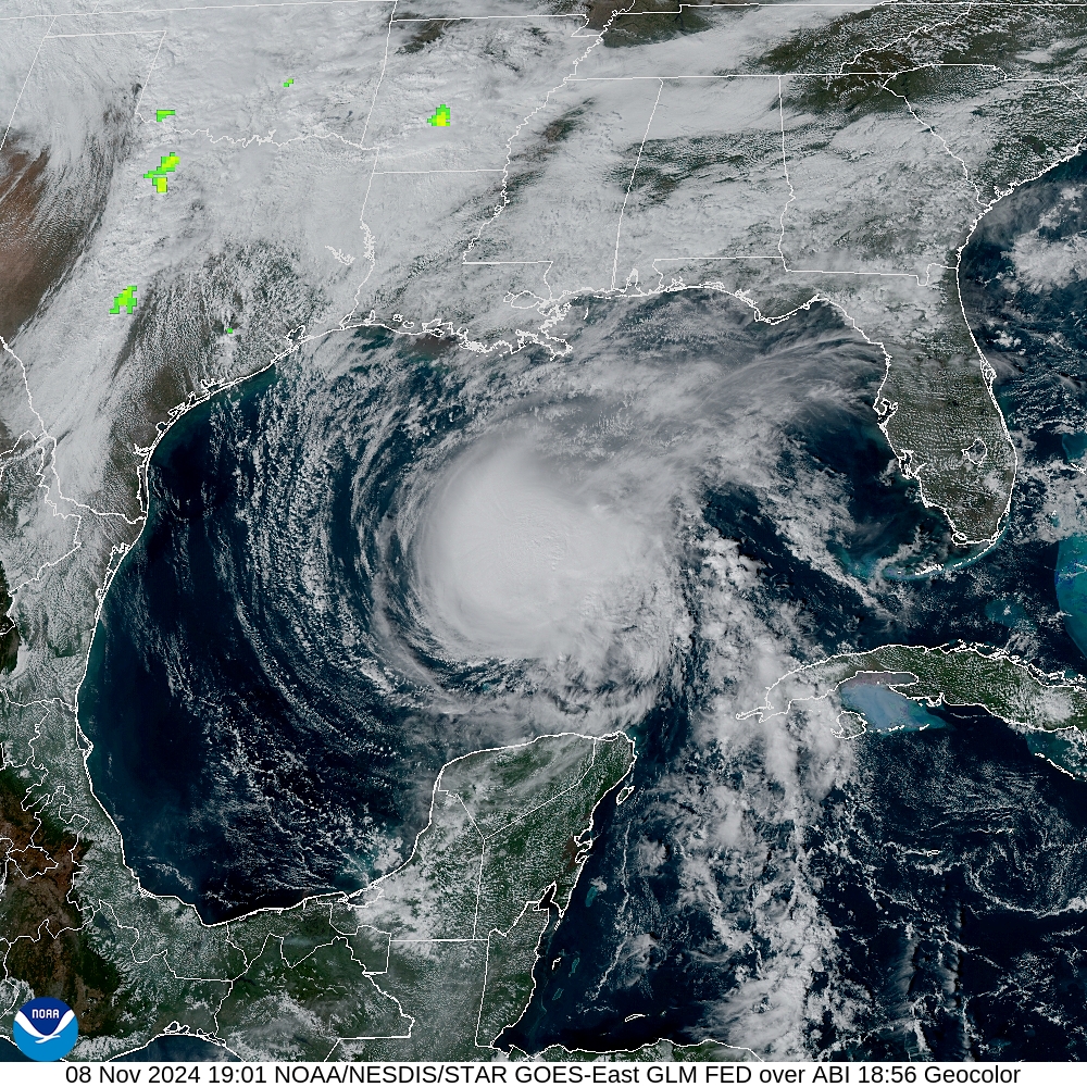
Adding to this November’s intense weather, Hurricane Rafael remains a force over the Gulf of Mexico, although it has begun to weaken. Initially a potent hurricane with winds exceeding 110 mph, Rafael continues to generate dangerous surf and rip currents along the Gulf Coast. Forecasts indicate it will gradually weaken as it moves westward, likely becoming a remnant low by early next week. Even in its weakened state, Rafael poses a prolonged threat to coastal communities, highlighting the rare occurrence of hurricanes in the Gulf this late in the year.
A Rare Weather Convergence for Early November
The overlapping impacts of winter storms, severe thunderstorms, and a Gulf hurricane in November underline the exceptional nature of this month’s weather patterns. Typically, severe thunderstorms and hurricanes have begun to wane by this time, making way for the gradual onset of winter. Yet, the U.S. is seeing all three weather phenomena unfold simultaneously, with one system impacting multiple regions in distinct and powerful ways.
This early-November convergence serves as a reminder of nature’s unpredictability and the challenges posed by rapid shifts in weather, from snow-packed mountain roads to severe thunderstorms in Texas and dangerous coastal conditions along the Gulf. The nation remains on high alert, with the potential for ongoing impacts as these systems unfold in the coming days.
